Back Pymble CEB Pymble German پیمبل (نیو ساوت ولز) Persian Pymble Malagasy Pymble, New South Wales Romanian Pymble Swedish پائمبل، نیوساؤتھ ویلز Urdu
| Pymble Sydney, New South Wales | |||||||||||||||
|---|---|---|---|---|---|---|---|---|---|---|---|---|---|---|---|
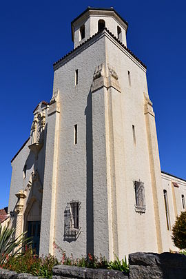
 Ku-ring-gai Town Hall, formerly the Sacred Heart Catholic Church. | |||||||||||||||
 | |||||||||||||||
| Population | 11,775 (2021 census)[1] | ||||||||||||||
| • Density | 1,808.8/km2 (4,685/sq mi) | ||||||||||||||
| Established | 1823 | ||||||||||||||
| Postcode(s) | 2073 | ||||||||||||||
| Elevation | 139 m (456 ft) | ||||||||||||||
| Area | 6.51 km2 (2.5 sq mi) | ||||||||||||||
| Location | 15 km (9 mi) north-west of Sydney CBD | ||||||||||||||
| LGA(s) | Ku-ring-gai Council | ||||||||||||||
| State electorate(s) | Davidson | ||||||||||||||
| Federal division(s) | Bradfield | ||||||||||||||
| |||||||||||||||

Pymble is a suburb on the Upper North Shore of Sydney in the state of New South Wales, Australia. Pymble is 15 kilometres (9 mi) north of the Sydney central business district in the local government area of Ku-ring-gai Council.[2]
West Pymble is a separate suburb to the south west of Pymble, adjacent to the Lane Cove National Park.
Pymble is notable for its gardens, bush reserves and heritage-listed residences and properties of architectural significance, such as the Eric Pratten House.
- ^ Australian Bureau of Statistics (28 June 2022). "Pymble". 2021 Census QuickStats. Retrieved 5 February 2024.
- ^ Google (5 February 2024). "Pymble, New South Wales" (Map). Google Maps. Google. Retrieved 5 February 2024.
{{cite map}}: Unknown parameter|name=ignored (help)
© MMXXIII Rich X Search. We shall prevail. All rights reserved. Rich X Search