| Quandialla New South Wales | |
|---|---|
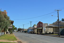
 Second Street, the main street of Quandialla | |
| Coordinates | 34°00′41″S 147°47′35″E / 34.01139°S 147.79306°E |
| Population | 349 (2011 census)[1] |
| Postcode(s) | 2721 |
| Elevation | 250 m (820 ft) |
| Location |
|
| LGA(s) | Weddin Shire |
| State electorate(s) | Cootamundra |
| Federal division(s) | Hume |
Quandialla is a village in the Central West region of New South Wales Australia. The town is 412 kilometres (256 mi) west of Sydney. It is situated on the plains of The Bland country at the western edge of the Weddin Shire. The town of Grenfell is 46 kilometres (29 mi) to the north-east, Young is 65 kilometres (40 mi) to the south-east and West Wyalong is 57 kilometres (35 mi) to the west. The Weddin Mountains are within sight.
At the 2011 census, Quandialla and the surrounding area had a population of 349.[1]
- ^ a b Australian Bureau of Statistics (31 October 2012). "Quandialla (State Suburb)". 2011 Census QuickStats. Retrieved 2 April 2015.
© MMXXIII Rich X Search. We shall prevail. All rights reserved. Rich X Search

