Back Quiapo, Manila BCL Quiapo (Manila) Spanish Quiapo Dutch Киапо Russian Quiapo, Maynila Tagalog Quiapo, Manila WAR 奎阿坡區 Chinese
Quiapo | |
|---|---|
District of Manila | |
 | |
 | |
| Country | Philippines |
| Region | National Capital Region |
| City | Manila |
| Congressional districts | Part of the 3rd district of Manila |
| Barangays | 16 |
| Founding Date | August 29, 1586 |
| Area | |
| • Total | 0.8469 km2 (0.3270 sq mi) |
| Population (2020)[1] | |
| • Total | 29,846 |
| • Density | 35,000/km2 (91,000/sq mi) |
| Time zone | UTC+08:00 (Philippine Standard Time) |
| Zip codes | 1001 |
| Area codes | 02 |
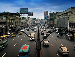
Quiapo ([ˈkjapɔʔ]) is a district of the city of Manila, in the National Capital Region of the Philippines. Known as the “Old Downtown of Manila", the district’s most famous landmark is Quiapo Church, a minor basilica enshrining Asia's most sacred Black Nazarene image, which has been processed every January in the historic district, attracting millions of devotees from all over the country and region. The historic district is also dotted with numerous heritage sites, ranging from ancestral and heritage houses such as those in Hidalgo Street, museums, art galleries, libraries, historic places of worship such as churches and mosques, historic cinemas, as well as historic parks and streets, many of which have been run over by informal settlers and the construction of shanty houses, as well as buildings built by corporations in the name of so-called "modernization". Many historic sites were destroyed by both the Japanese and American colonizers during World War II without compensation or aid for reconstruction, while some post-war sites were demolished by certain corporations. In recent years, various heritage organizations, experts, and lawmakers have pushed for the re-vitalization of Quiapo as a heritage zone, including the rebuilding of lost heritage structures, the revamping of modern structures to fit the historic district's original aesthetics, as well as the planting of trees and plants and the refurnishing of streets to make the district more safe, walkable, and climate-adaptive.
Geographically located at the very center of the City of Manila, Quiapo is bounded by the Pasig River and Estero de San Miguel to the south, San Miguel district to the east, the districts of Sampaloc and Santa Cruz and Recto Avenue to the north, and the Santa Cruz district and Rizal Avenue to the west.
- ^ "2020 Census of Population and Housing Results" (PDF). Philippine Statistics Authority. August 16, 2021. Retrieved April 7, 2023.
© MMXXIII Rich X Search. We shall prevail. All rights reserved. Rich X Search