Back محمية مينسمير الطبيعيه ARZ Minsmere Nature Reserve CEB Réserve naturelle de Minsmere French RSPB Minsmere ID RSPB Minsmere JV RSPB Minsmere MIN Minsmere Nature Reserve Swedish
| RSPB Minsmere | |
|---|---|
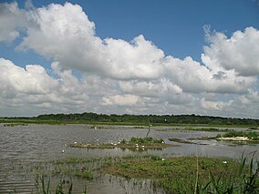
 Looking west over the scrape, an area of shallow water and bare mud | |
Minsmere RSPB reserve shown within Suffolk | |
| Location | Suffolk, East of England, England |
| Coordinates | 52°14′33″N 01°36′50″E / 52.24250°N 1.61389°E |
| Established | 1947 |
| Operator | Royal Society for the Protection of Birds |
| Website | www |
| Official name | Minsmere - Walberswick |
| Designated | 5 January 1976 |
| Reference no. | 75[1] |
RSPB Minsmere is a nature reserve owned and managed by the Royal Society for the Protection of Birds (RSPB) at Minsmere, Suffolk. The 1,000-hectare (2,500-acre) site has been managed by the RSPB since 1947 and covers areas of reed bed, lowland heath, acid grassland, wet grassland, woodland and shingle vegetation. It lies within the Suffolk Coast and Heaths Area of Outstanding Natural Beauty and the Suffolk Heritage Coast area. It is conserved as a Site of Special Scientific Interest, Special Area of Conservation, Special Protection Area and Ramsar site.
The nature reserve is managed primarily for bird conservation, particularly through control and improvement of wetland, heath and grassland habitats, with particular emphasis on encouraging nationally uncommon breeding species such as the bittern, stone-curlew, marsh harrier, nightjar and nightingale. The diversity of habitats has also led to a wide variety of other animals and plants being recorded on the site.
Before becoming a nature reserve, the area was the site of an ancient abbey and a Tudor artillery battery. The marshes were reclaimed as farmland in the 19th century, but were re-flooded during World War II as a protection against possible invasion.
The reserve has a visitor centre, eight bird hides and an extensive network of footpaths and trails. Entry is free for RSPB members. Potential future threats to the site include flooding or salination as climate change causes rising sea levels, coastal erosion and possible effects on water levels due to the construction of a new reactor at the neighbouring Sizewell nuclear power stations.
- ^ "Minsmere - Walberswick". Ramsar Sites Information Service. Retrieved 25 April 2018.
© MMXXIII Rich X Search. We shall prevail. All rights reserved. Rich X Search
