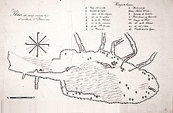
| Rancho San Francisco | |
|---|---|
 1843 map of Rancho San Francisco | |
| Location | Northwestern Los Angeles County and eastern Ventura County, California |
| Coordinates | 34°26′02″N 118°36′28″W / 34.43389°N 118.60778°W |
| Area | 48,612 acres (19,673 ha) |
| Established | January 22, 1839 |
| Official name | Rancho San Francisco[1] |
| Reference no. | 556 |
| Official name | Oak of the Golden Dream[1] |
| Reference no. | 168 |
Rancho San Francisco was a land grant in present-day northwestern Los Angeles County and eastern Ventura County, California. It was a grant of 48,612 acres (19,673 ha) by Governor Juan B. Alvarado to Antonio del Valle, a Mexican army officer, in recognition for his service to Alta California.[2][3] It is not related to the city of San Francisco.
The rancho is the location of the first popularly known finding of gold in the Southern California area in 1842, in Placerita Canyon.[4] Much of the present day city of Santa Clarita lies within the boundary of what was Rancho San Francisco. The adobe headquarters of the rancho, and the site of the gold find (known today as the "Oak of the Golden Dream"), are designated California Historical Landmarks.[1] The rancho included portions of the San Gabriel, Santa Susana, Topatopa, and Sierra Pelona Mountain ranges.
- ^ a b c Cite error: The named reference
ohpwas invoked but never defined (see the help page). - ^ Cite error: The named reference
hansonwas invoked but never defined (see the help page). - ^ "The Del Valle Family". Rancho Camulos Museum: The Home of Ramona. 2009. Retrieved September 3, 2012.
- ^ Rawls, James; Orsi, Richard J., eds. (1999). A golden state: mining and economic development in Gold Rush California. California History Sesquicentennial, 2. Berkeley and Los Angeles: University of California Press. p. 3. ISBN 0-520-21771-3.
© MMXXIII Rich X Search. We shall prevail. All rights reserved. Rich X Search
