Back Ridgefield (Connecticut) Catalan Риджфилд (Коннектикут) CE Ridgefield (lungsod sa Tinipong Bansa, Connecticut) CEB Ridgefield, Connecticut Welsh Ridgefield (Connecticut) German Ridgefield (Connecticut) Spanish Ridgefield (Connecticut) Basque Ridgefield (Connecticut) French Ridgefield, Connecticut HT Ridgefield (Connecticut, város) Hungarian
This article needs additional citations for verification. (May 2014) |
Ridgefield, Connecticut | |
|---|---|
| Town of Ridgefield | |
 Ridgefield Town Hall | |
| Coordinates: 41°18′19″N 73°30′05″W / 41.30528°N 73.50139°W | |
| Country | |
| U.S. state | |
| County | Fairfield |
| Region | Western CT |
| Incorporated | 1709 |
| Villages | Ridgefield Branchville Ridgebury Titicus Farmingville |
| Government | |
| • Type | Selectman-town meeting |
| • First selectman | Rudy Marconi (D) |
| • Selectmen | Sean Connelly (D) Barbara Manners (D) Bob Hebert (R) Maureen Kozlark (U) |
| • Connecticut House of Representatives | Aimee Berger-Girvalo (D) Rachel Chaleski (R) |
| Area | |
| • Total | 35.0 sq mi (90.6 km2) |
| • Land | 34.4 sq mi (89.2 km2) |
| • Water | 0.5 sq mi (1.4 km2) |
| Elevation | 659 ft (201 m) |
| Population (2020) | |
| • Total | 7,655 |
| • Density | 727.7/sq mi (281.0/km2) |
| Time zone | UTC−5 (Eastern) |
| • Summer (DST) | UTC−4 (Eastern) |
| ZIP Code | 06877 |
| Area code(s) | 203/475 |
| FIPS code | 09-63970 |
| GNIS feature ID | 0213496 |
| Website | www |
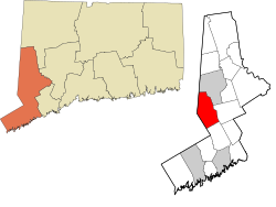
Ridgefield is a town in Fairfield County, Connecticut, United States. Situated in the foothills of the Berkshire Mountains and on the New York state border, Ridgefield has a population of 7,655 as of the 2020 census.[1] The town is part of the Western Connecticut Planning Region. The town center, which was formerly a borough, is defined by the U.S. Census Bureau as a census-designated place. The town was settled then quickly incorporated by 1709.[2]
- ^ "Census - Geography Profile: Ridgefield town, Fairfield County, Connecticut". United States Census Bureau. Retrieved December 20, 2021.
- ^ Cite error: The named reference
:0was invoked but never defined (see the help page).
© MMXXIII Rich X Search. We shall prevail. All rights reserved. Rich X Search


