Back مقاطعة رايبلي (ميزوري) Arabic Ripley County, Missouri BAR Рипли (окръг, Мисури) Bulgarian রিপ্লেয় কাউন্টি, মিসৌরি BPY Ripley Gông (Missouri) CDO Рипли (гуо, Миссури) CE Ripley County (kondado sa Tinipong Bansa, Missouri) CEB Ripley County, Missouri Welsh Ripley County (Missouri) German Condado de Ripley (Misuri) Spanish
Ripley County | |
|---|---|
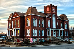
 Ripley County Courthouse in Doniphan | |
 Location within the U.S. state of Missouri | |
 Missouri's location within the U.S. | |
| Coordinates: 36°40′N 90°52′W / 36.66°N 90.87°W | |
| Country | |
| State | |
| Founded | January 5, 1833 |
| Named for | Eleazer Wheelock Ripley |
| Seat | Doniphan |
| Largest city | Doniphan |
| Area | |
| • Total | 632 sq mi (1,640 km2) |
| • Land | 630 sq mi (1,600 km2) |
| • Water | 2.1 sq mi (5 km2) |
| Population (2020) | |
| • Total | 10,679 |
| • Density | 17/sq mi (6.5/km2) |
| Time zone | UTC−6 (Central) |
| • Summer (DST) | UTC−5 (CDT) |
| Congressional district | 8th |
| Website | www |
Ripley County is a county in the Ozarks of Missouri. At the 2020 census, it had a population of 10,679.[1] The largest city and county seat is Doniphan.[2] The county was officially organized on January 5, 1833, and is named after Brigadier General Eleazer Wheelock Ripley, a soldier who served with distinction in the War of 1812.[3]
The original area included what would later become Oregon, Howell, Shannon and Carter counties. The historic Natchitoches Trail passes through Ripley County. It was a Native American trail to the Southwest that was used by pioneers, including Stephen F. Austin. During the American Civil War, Ripley County was strongly pro-Southern and provided four colonels for the Confederate Army. Several Civil War skirmishes took place in the county. Tourist areas include the Current River and the Mark Twain National Forest.
- ^ "State & County QuickFacts". United States Census Bureau. Retrieved September 12, 2013.
- ^ "Find a County". National Association of Counties. Retrieved June 7, 2011.
- ^ Eaton, David Wolfe (1917). How Missouri Counties, Towns and Streams Were Named. The State Historical Society of Missouri. pp. 347.
© MMXXIII Rich X Search. We shall prevail. All rights reserved. Rich X Search