Back Granta ANG نهر كام Arabic نهر كام ARZ Кам (рака) BE-X-OLD Riu Cam (Cambridgeshire) Catalan River Cam (suba sa Hiniusang Gingharian, Cambridgeshire) CEB Cam (řeka) Czech Afon Cam Welsh River Cam (Great Ouse) German Río Cam Spanish
| Cam | |
|---|---|
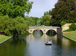
 View north towards Clare College bridge in Cambridge | |
Location of the River Cam's mouth in Cambridgeshire | |
| Location | |
| Country | England |
| County | Cambridgeshire |
| Physical characteristics | |
| Source | |
| • location | south of Debden |
| • coordinates | 51°57′37″N 0°16′18″E / 51.9602°N 0.2718°E |
| • elevation | 112 m (367 ft) |
| Mouth | River Great Ouse |
• location | east of Stretham |
• coordinates | 52°20′54″N 0°15′09″E / 52.3483°N 0.2525°E |
• elevation | 2 m (6 ft 7 in) |
| Length | 69.4 km (43.1 mi) |
| Basin features | |
| River system | River Great Ouse |
| Tributaries | |
| • left | Bourn Brook |
The River Cam (/ˈkæm/) is the main river flowing through Cambridge in eastern England. After leaving Cambridge, it flows north and east before joining the River Great Ouse to the south of Ely, at Pope's Corner. The total distance from Cambridge to the sea is about 40 mi (64 km) and is navigable for punts, small boats, and rowing craft. The Great Ouse also connects to England's canal system via the Middle Level Navigations and the River Nene. In total, the Cam runs for around 69 kilometres (43 mi) from its furthest source (near Debden in Essex) to its confluence with the Great Ouse.
© MMXXIII Rich X Search. We shall prevail. All rights reserved. Rich X Search
