Back Riu Corrib Catalan River Corrib CEB Корриб CV Corrib German Río Corrib Spanish Corrib ibaia Basque Corrib (fleuve) French Abhainn na Gaillimhe Irish Río Corrib Galician Corrib (fiume) Italian
| River Corrib | |
|---|---|
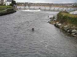
 Looking north from the Salmon Weir Bridge in Galway | |
| Etymology | Stony |
| Native name | Abhainn na Gaillimhe (Irish) |
| Location | |
| Country | Ireland |
| Physical characteristics | |
| Source | |
| • location | Lough Corrib |
| Mouth | |
• location | Galway Bay and Atlantic Ocean at the Claddagh |
• coordinates | 53°16′02″N 9°02′46″W / 53.26717°N 9.04599°W |
| Length | 6 kilometres (3.7 mi) |
| Basin size | 3,101 km2 (1,197 sq mi) |
| Discharge | |
| • average | 104.8 m3/s (3,700 cu ft/s) |

The River Corrib (Irish: Abhainn na Gaillimhe) in the west of Ireland flows from Lough Corrib through Galway to Galway Bay. The river is among the shortest in Europe, with only a length of six kilometres from the lough to the Atlantic. It is popular with local whitewater kayakers as well as several rowing clubs and pleasure craft. The depth of this river reaches up to 94 feet.[1]
The Corrib drains a catchment area of 3,138 km2.[2]
Although the Corrib is one of Ireland's shortest rivers, it has a mean long-term flow rate of 104.8 m3/s, making it Ireland's second-largest river (by flow), only surpassed by the River Shannon.[2][3][4]
- ^ http://www.npws.ie/sites/default/files/publications/pdf/IWM26.pdf [bare URL PDF]
- ^ a b "South Eastern River Basin District Management system : Initial Characterisation Report : Physical Description" (PDF). Serbd.com. Archived from the original (PDF) on 3 March 2016. Retrieved 2 March 2015.
- ^ SMILE – Sustainable Mariculture in northern Irish Lough Ecosystems Archived 12 November 2013 at the Wayback Machine. Ecowin.org. Retrieved on 23 July 2013.
- ^ Inland fisheries of Europe. Fao.org. Retrieved on 23 July 2013.
© MMXXIII Rich X Search. We shall prevail. All rights reserved. Rich X Search