Back River Deben CEB River Deben German رود دبن Persian Deben (fleuve) French Deben Italian River Deben Swedish
This article needs additional citations for verification. (January 2017) |
| Deben | |
|---|---|
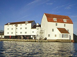
 Woodbridge Tide Mill from the River Deben | |
| Location | |
| Country | England |
| Region | Suffolk |
| Physical characteristics | |
| Source | Bedingfield |
| • coordinates | 52°15′34″N 1°11′14″E / 52.2594°N 1.1873°E |
| • elevation | 60 m (200 ft) |
| 2nd source | Debenham |
| • coordinates | 52°13′35″N 1°08′01″E / 52.2263°N 1.1336°E |
| • elevation | 54 m (177 ft) |
| Mouth | North Sea near Felixstowe |
• coordinates | 51°58′51″N 1°23′34″E / 51.9808°N 1.3927°E |
• elevation | 0 m (0 ft) |
| Length | 54 km (34 mi) |
| Basin features | |
| Tributaries | |
| • right | |
The River Deben is a river in Suffolk rising to the west of Debenham, though a second, higher source runs south from the parish of Bedingfield. The river passes through Woodbridge, turning into a tidal estuary before entering the North Sea at Felixstowe Ferry. The mouth of the estuary is crossed by a ferry connecting Felixstowe and Bawdsey.[1]
- ^ Ordnance Survey of Great Britain
© MMXXIII Rich X Search. We shall prevail. All rights reserved. Rich X Search
