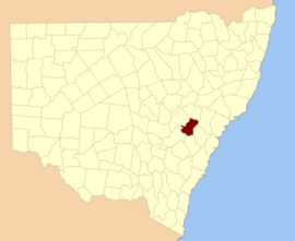
| Roxburgh New South Wales | |||||||||||||||
|---|---|---|---|---|---|---|---|---|---|---|---|---|---|---|---|
 Location in New South Wales | |||||||||||||||
| |||||||||||||||

Roxburgh County was one of the original Nineteen Counties in New South Wales and is now one of the 141 Cadastral divisions of New South Wales. It includes the area to the north east of Bathurst, lying to the north and east of the Fish River to the junction of the Turon River. It includes Sofala. The Gudgegong River is the border to the north.
Roxburgh County named after the Scottish county of the same name. It was named in 1829.[1]
- ^ "Roxburgh". Geographical Names Register (GNR) of NSW. Geographical Names Board of New South Wales.
© MMXXIII Rich X Search. We shall prevail. All rights reserved. Rich X Search
