Back جبال روبي Arabic جبال روبى ARZ Muntanyes Ruby Catalan Ruby Mountains CEB Ruby Mountains Czech Montañas Ruby Spanish کوههای روبی Persian Chaîne Ruby French रुबी पर्वतरांग Marathi
This article needs additional citations for verification. (June 2024) |
| Ruby Mountains | |
|---|---|
 Peaks around Ruby Dome | |
| Highest point | |
| Peak | Ruby Dome |
| Elevation | 11,387 ft (3,471 m) |
| Coordinates | 40°37′18″N 115°28′31″W / 40.62167°N 115.47528°W[1] |
| Dimensions | |
| Length | 80 mi (130 km) North-South |
| Width | 11 mi (18 km)[2] |
| Geography | |
| Country | United States |
| State | Nevada |
| County | Elko |
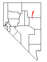
The Ruby Mountains (Shoshoni: 'Duka Doya', meaning “Snowcapped”)[3] are a mountain range, primarily located within Elko County with a small extension into White Pine County, in Nevada, United States. The mountain range was named after the garnets found by early explorers.[citation needed] The central core of the range shows extensive evidence of glaciation during recent ice ages, including U-shaped canyons, moraines, hanging valleys, and steeply carved granite mountains, cliffs, and cirques.[citation needed]
- ^ "Ruby Dome Cairn". NGS Data Sheet. National Geodetic Survey, National Oceanic and Atmospheric Administration, United States Department of Commerce. Retrieved 4 September 2022.
- ^ "Backpacking In The Ruby Mountains". Retrieved 1 June 2010.
- ^ Unlimited, National Wildlife Federation, Rocky Mountain Wild, and Trout (14 June 2022). "Little Potential for Development, High Potential for Harm". ArcGIS StoryMaps. Retrieved 12 November 2023.
{{cite web}}: CS1 maint: multiple names: authors list (link)
© MMXXIII Rich X Search. We shall prevail. All rights reserved. Rich X Search
