Back Rugosa CEB Rugged Island (Südliche Shetlandinseln) German Isla Rugosa Spanish Île Rugged French ראגד (אי, איי שטלנד הדרומיים) HE Isola Rugged Italian ラギッド島 Japanese Rugged Island i Sør-Shetlandsøyane NN Rugged Island Polish Rugged Island Swedish
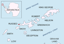
 Location of Rugged Island in the South Shetland Islands | |
 | |
| Geography | |
|---|---|
| Location | Antarctica |
| Coordinates | 62°38′S 61°15′W / 62.633°S 61.250°W |
| Archipelago | South Shetland Islands |
| Area | 10.4 km2 (4.0 sq mi) |
| Length | 3 mi (5 km) |
| Width | 1 mi (2 km) |
| Administration | |
| Administered under the Antarctic Treaty System | |
| Demographics | |
| Population | uninhabited |


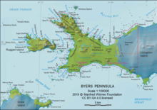
Rugged Island (in Spanish Isla Rugosa, variant historical names Lloyds Island or Ragged Island) is an island 3 miles (4.8 km) long and 1 mile (1.6 km) wide, lying west of Livingston Island in the South Shetland Islands. Its surface area is 10.4 square kilometres (4.0 sq mi).[1] The island's summit San Stefano Peak rises to 256 metres (840 ft) above sea level. Rugged Island is located at 62°38′S 61°15′W / 62.633°S 61.250°W. Rugged Island was known to both American and British sealers as early as 1820, and the name has been well established in international usage for over 100 years.
- ^ L.L. Ivanov. Antarctica: Livingston Island and Greenwich, Robert, Snow and Smith Islands. Scale 1:120000 topographic map. Troyan: Manfred Wörner Foundation, 2010. ISBN 978-954-92032-9-5 (First edition 2009. ISBN 978-954-92032-6-4)
© MMXXIII Rich X Search. We shall prevail. All rights reserved. Rich X Search