Back منطقة سانجرور Arabic سانجرور ARZ संगरूर जिला Bihari Sangrur (distrito sa Indiya) CEB Sangrur (Distrikt) German Distrito de Sangrur Spanish Sangrur barrutia Basque بخش سنگرور Persian Sangrurin piirikunta Finnish District de Sangrur French
Sangrur district | |
|---|---|
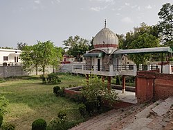
 Rajarajeshwari Temple in Sangrur | |
 Location in Punjab | |
| Coordinates: 30°14′N 75°50′E / 30.23°N 75.83°E | |
| Country | |
| State | Punjab |
| Headquarters | Sangrur |
| Area | |
| • Total | 2,848 km2 (1,100 sq mi) |
| Elevation | 232 m (761 ft) |
| Population (2011) | |
| • Total | 1,225,415 |
| • Density | 430/km2 (1,100/sq mi) |
| Languages | |
| • Official | Punjabi |
| Time zone | UTC+5:30 (IST) |
| PIN | 148001 |
| Telephone code | 01672 |
| Vehicle registration | PB 13 |
| Website | sangrur |
Sangrur district is in the state of Punjab in northern India. Sangrur city is the district headquarters. It is one of the five districts in Patiala Division in the Indian state of Punjab.[1] Neighbouring districts are Malerkotla (north), Barnala (west), Patiala (east), Mansa (southwest) and Fatehabad (Haryana) and Jind (Haryana) (south).
Sangrur consists of the cities of Dhuri, Lehragaga, Sangrur, and Sunam. Other cities are Bhawanigarh, Dirba, Khanauri, Longowal, Cheema and Moonak. There are 7 sub-divisions, being Sangrur, Dhuri, Sunam, Lehragaga, Moonak, Bhawanigarh and Dirba. Till 2006, Barnala was also a part of Sangrur district, but now it is a separate district. In 2021, a new district Malerkotla district, consisting of Malerkotla and Ahmedgarh subdivisions and the Amargarh sub-tehsil, was formed out of Sangrur district.[2]
- ^ "Sangrur, Punjab". Government of Punjab. Retrieved 5 June 2020.
- ^ "Malerkotla is Punjab's 23rd district". The Hindu. 14 May 2021. ISSN 0971-751X. Retrieved 14 May 2021.
© MMXXIII Rich X Search. We shall prevail. All rights reserved. Rich X Search