Back منطقة سيهوري Arabic سيهورى ARZ सीहोर जिला Bihari সিহোর জেলা Bengali/Bangla Sehore (distrito) CEB Sehore (Distrikt) German Distrito de Sehore Spanish Sehore barrutia Basque بخش سهور Persian District de Sehore French
Sehore District | |
|---|---|
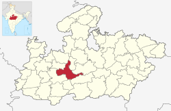
 Location of Sehore district in Madhya Pradesh | |
| Coordinates (Sehore): 23°12′N 77°05′E / 23.200°N 77.083°E | |
| Country | India |
| State | Madhya Pradesh |
| Division | Bhopal |
| Headquarters | Sehore |
| Tehsils | 8: |
| Government | |
| • Lok Sabha constituencies | Bhopal |
| Area | |
| • Total | 6,578 km2 (2,540 sq mi) |
| Population (2011) | |
| • Total | 1,311,332 |
| • Density | 200/km2 (520/sq mi) |
| Demographics | |
| • Literacy | 70.06% |
| • Sex ratio | 918 |
| Time zone | UTC+05:30 (IST) |
| Major highways | Bhopal-Indore Highway |
| Website | sehore |
Sehore District is a district of Madhya Pradesh state in central India. The town of Sehore is the district headquarters. The district is part of Bhopal Division.
© MMXXIII Rich X Search. We shall prevail. All rights reserved. Rich X Search


