Back سمنان (محافظة) Arabic سمنان (محافظه) ARZ Provincia de Semnán AST Семнан (остан) AV Simnan ostanı Azerbaijani سیمنان اوستانی AZB Семнан (астан) Byelorussian Сэмнан (астан) BE-X-OLD Семнан (остан) Bulgarian সেম্নন প্রদেশ Bengali/Bangla
Semnan Province
Persian: استان سمنان | |
|---|---|
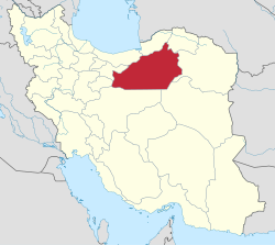
 Location of Semnan Province within Iran | |
 | |
| Coordinates: 35°11′N 54°25′E / 35.183°N 54.417°E[2] | |
| Country | Iran |
| Region | Region 1[1] |
| Capital | Semnan |
| Counties | 8 |
| Government | |
| • Governor-general | Mohammad-Reza Hashemi |
| • MPs of Assembly of Experts | Mohammad Shahcheraghi |
| • Representative of the Supreme Leader | Morteza Motiei |
| Area | |
| • Total | 97,491 km2 (37,641 sq mi) |
| Population (2016)[3] | |
| • Total | 702,360 |
| • Density | 7.2/km2 (19/sq mi) |
| Time zone | UTC+03:30 (IRST) |
| ISO 3166 code | IR-20 |
| Main language(s) | Semnani languages, Persian |
| HDI (2019) | 0.807[4] very high · 4th |
Semnan Province (Persian: استان سمنان)[a] is one of the 31 Provinces of Iran. It is in the north of the country. Its capital is the city of Semnan.[5] The province of Semnan covers an area of 96,816 square kilometers and stretches along the Alborz mountain range, bordering on Kavir desert in its southern parts.
At the time of the 2006 National Census, the population of the province was 570,835 in 159,791 households.[6] The following census in 2011 counted 631,218 people in 186,114 households.[7] The province was made part of Region 1 following the division of the provinces into 5 regions, solely for coordination and development purposes, on June 22, 2014.[1] By the time of the most recent census of 2016, the population had risen to 702,360 in 215,571 households.[3]
Various ethnic groups with Kurdish, Turkish, Lor, Arab, Baloch and Gilak origins are settled in this province and it is also known as the Island of the Tribes due to the variety of ethnic groups living in the province.[8]
Semnan province is located on the southern slopes of the Alborz mountain range. The height of the province decreases from north to south until it reaches the desert. The area of this province is 96000 square kilometers and it is 5.6% of the area of Iran.[9]
- ^ a b "استانهای کشور به ۵ منطقه تقسیم شدند". همشهری آنلاین. 22 June 2014. Retrieved 4 February 2024.
- ^ OpenStreetMap contributors (24 May 2024). "Semnan Province" (Map). OpenStreetMap. Retrieved 24 May 2024.
- ^ a b "Census of the Islamic Republic of Iran, 1395 (2016)". AMAR (in Persian). The Statistical Center of Iran. p. 20. Archived from the original (Excel) on 17 November 2020. Retrieved 19 December 2022.
- ^ "Sub-national HDI - Area Database - Global Data Lab". hdi.globaldatalab.org. Retrieved 13 September 2018.
- ^ Habibi, Hassan (21 June 1369). "Approval of the organization and chain of citizenship of the elements and units of the national divisions of Semnan province, centered in Semnan city". Lamtakam (in Persian). Ministry of Interior, Defense Political Commission of the Government Council. Archived from the original on 2 January 2024. Retrieved 2 January 2024.
- ^ "Census of the Islamic Republic of Iran, 1385 (2006)". AMAR (in Persian). The Statistical Center of Iran. p. 20. Archived from the original (Excel) on 20 September 2011. Retrieved 25 September 2022.
- ^ "Census of the Islamic Republic of Iran, 1390 (2011)". Syracuse University (in Persian). The Statistical Center of Iran. p. 20. Archived from the original (Excel) on 20 January 2023. Retrieved 19 December 2022.
- ^ Tourism Magazine [dead link]
- ^ ایران, عصر. "از استان سمنان چه می دانید؟". asriran.com (in Persian). Retrieved 21 August 2023.
Cite error: There are <ref group=lower-alpha> tags or {{efn}} templates on this page, but the references will not show without a {{reflist|group=lower-alpha}} template or {{notelist}} template (see the help page).
© MMXXIII Rich X Search. We shall prevail. All rights reserved. Rich X Search