Back শেরপুর উপজেলা Bengali/Bangla শেরপুর উপজিলা BPY Sherpur (subdistrito) CEB Sherpur Spanish شرپور Persian Sherpur French शेरपुर उपज़िला Hindi Sherpur Italian शेरपुर उपजिल्ला Nepali Шерпур (подокруг) Russian
Sherpur
শেরপুর | |
|---|---|
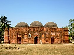
 Kherua Mosque | |
 | |
| Coordinates: 24°40′N 89°25′E / 24.667°N 89.417°E | |
| Country | |
| Division | Rajshahi |
| District | Bogra |
| Area | |
| • Total | 295.93 km2 (114.26 sq mi) |
| Population (2011 census)[1] | |
| • Total | 332,825 |
| • Density | 1,100/km2 (2,900/sq mi) |
| Time zone | UTC+6 (BST) |
| Postal code | 5840 to 5842 |
| Website | sherpur |
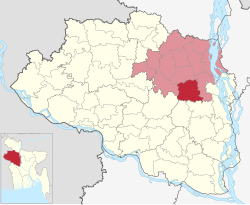
Sherpur Upazila (Bengali: শেরপুর উপজেলা) is an upazila of Bogra District in the Division of Rajshahi, Bangladesh. Sherpur Thana was established in 1962 and was converted into an upazila in 1983.[2] It is named after its administrative center, the town of Sherpur. It is said that there once lived Sher (Bengali: শের, tiger) family in the vicinity, from which the name "Sherpur" evolved.[citation needed]
© MMXXIII Rich X Search. We shall prevail. All rights reserved. Rich X Search