Back Serpentine-Jarrahdale CEB Serpentine-Jarrahdale Shire German Comté de Serpentine-Jarrahdale French Contea di Serpentine-Jarrahdale Italian Shire of Serpentine-Jarrahdale Dutch Hrabstwo Serpentine-Jarrahdale Polish Serpentine-Jarrahdale Shire Swedish
| Shire of Serpentine-Jarrahdale Western Australia | |||||||||||||||
|---|---|---|---|---|---|---|---|---|---|---|---|---|---|---|---|
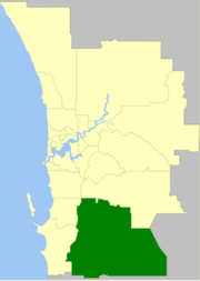
 The Shire of Serpentine-Jarrahdale within the Perth Metropolitan Area | |||||||||||||||
 | |||||||||||||||
| Population | 32,173 (LGA 2021)[1] | ||||||||||||||
| Established | 1894 | ||||||||||||||
| Area | 905 km2 (349.4 sq mi) | ||||||||||||||
| Shire President | Rob Coales | ||||||||||||||
| Council seat | Mundijong | ||||||||||||||
| Region | Peel region | ||||||||||||||
| State electorate(s) | Darling Range | ||||||||||||||
| Federal division(s) | Canning | ||||||||||||||
 | |||||||||||||||
| Website | Shire of Serpentine-Jarrahdale | ||||||||||||||
| |||||||||||||||
The Shire of Serpentine-Jarrahdale is a local government area in the outer southeastern metropolitan area of Perth, the capital of Western Australia, and has an area of 905 square kilometres (349 sq mi) and a population of 32,173 as at the 2021 Census. Despite being named after two towns in the area, neither Serpentine nor Jarrahdale function as either the Shire's largest settlement (Byford) or the seat of government (Mundijong).
- ^ Australian Bureau of Statistics (28 June 2022). "Serpentine-Jarrahdale (Local Government Area)". Australian Census 2021 QuickStats. Retrieved 28 June 2022.
© MMXXIII Rich X Search. We shall prevail. All rights reserved. Rich X Search