Back Sibford Gower CEB Sibford Gower Spanish Sibford Gower French Sibford Gower Italian Sibford Gower LLD Sibford Gower Dutch Sibford Gower Polish Sibford Gower Swedish Sibford Gower Turkish Sibford Gower ZH-MIN-NAN
| Sibford Gower | |
|---|---|
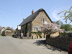
 The Wykham Arms | |
Location within Oxfordshire | |
| Area | 7.09 km2 (2.74 sq mi) |
| Population | 508 (parish, including Burdrop) (2011 Census) |
| • Density | 72/km2 (190/sq mi) |
| OS grid reference | SP3537 |
| Civil parish |
|
| District | |
| Shire county | |
| Region | |
| Country | England |
| Sovereign state | United Kingdom |
| Post town | Banbury |
| Postcode district | OX15 |
| Dialling code | 01295 |
| Police | Thames Valley |
| Fire | Oxfordshire |
| Ambulance | South Central |
| UK Parliament | |
| Website | The Sibfords Society |
Sibford Gower is a village and civil parish about 6.5 miles (10.5 km) west of Banbury in Oxfordshire, on the north side of the Sib valley, opposite Sibford Ferris. Sibford Gower parish includes the village of Burdrop. The 2011 Census recorded the parish's population as 508.[1] Much of the village is a conservation area.[2]
- ^ "Area: Sibford Gower (Parish): Key Figures for 2011 Census: Key Statistics". Neighbourhood Statistics. Office for National Statistics. Retrieved 13 February 2015.
- ^ Design and Conservation Team Strategic Planning and the Economy. “Sibford Ferris, Sibford Gower and Burdrop Conservation Area Appraisal.” Thesibfords.uk, Cherwell, 2012, https://thesibfords.uk/sib2/wp-content/uploads/2019/02/SIbford_Ferris__Gower___Burdrop_CA_Appraisal_2012.pdf.
© MMXXIII Rich X Search. We shall prevail. All rights reserved. Rich X Search
