South 24 Parganas

South 24 Parganas
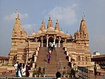
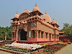
Clockwise from top: Gangasagar Kapilmuni Temple, Bawali Rajbari, Nimpith Ramkrishna Mission Ashram, Royal Bengal Tiger in the Sundarbans, BAPS Shri Swaminarayan Temple in Pailan, Jatar Deul
Location of South 24 Parganas in West Bengal
Coordinates: 22°10′53″N 88°32′16″E / 22.1815262°N 88.53780484°E / 22.1815262; 88.53780484
Country India
State West Bengal
DivisionPresidency
HeadquartersAlipore
Government
 • SubdivisionsAlipore Sadar, Baruipur, Canning, Diamond Harbour, Kakdwip
 • CD BlocksThakurpukur Maheshtala, Budge Budge I, Budge Budge II, Bishnupur I, Bishnupur II, Bhangar I, Bhangar II, Sonarpur, Baruipur, Jaynagar I, Jaynagar II, Kultali, Canning I, Canning II, Basanti, Gosaba, Falta, Magrahat I, Magrahat II, Diamond Harbour I, Diamond Harbour II, Mandirbazar, Mathurapur I, Mathurapur II, Kulpi, Kakdwip, Namkhana, Patharpratima, Sagar
 • Lok Sabha constituenciesJaynagar (SC), Mathurapur (SC), Diamond Harbour, Jadavpur, Kolkata Dakshin
 • Vidhan Sabha constituenciesGosaba (SC), Basanti (SC), Kultali (SC), Patharpratima, Kakdwip, Sagar, Kulpi, Raidighi, Mandirbazar (SC), Jaynagar (SC), Baruipur Purba (SC), Canning Paschim (SC), Canning Purba, Baruipur Paschim, Magrahat Purba (SC), Magrahat Paschim, Diamond Harbour, Falta, Satgachia, Bishnupur (SC), Sonarpur Dakshin, Bhangar, Sonarpur Uttar, Behala Purba, Maheshtala, Budge Budge, Metiaburuz, Jadavpur, Tollyganj, Kasba, Behala Paschim
Area
 • Total9,960 km2 (3,850 sq mi)
Population
 (2011)
 • Total8,161,961
 • Density820/km2 (2,100/sq mi)
 • Urban
2,087,773
Demographics
 • Literacy78.57 per cent
 • Sex ratio949 /
Languages
 • OfficialBengali[1][2]
 • Additional officialEnglish[1]
Time zoneUTC+05:30 (IST)
Vehicle registrationWB-19 to WB-22, WB-95 to WB-99
Major highwaysNH-12, SH-1, SH-3
Average annual precipitation1750 mm
Websitewww.s24pgs.gov.in

South 24 Parganas (Pron: pɔrɡɔnɔs; abbr. 24 PGS (S)), or sometimes South Twenty Four Parganas and Dakshin 24 Parganas, is a district in the Indian state of West Bengal, headquartered in Alipore. It is the largest district of West Bengal by area and second largest by population. It is the sixth most populous district in India (out of 640). On one side of the district there is the urban fringe of Kolkata, and on the other the remote riverine villages in the Sundarbans.[3]

  1. ^ a b "Fact and Figures". Wb.gov.in. Retrieved 5 July 2019.
  2. ^ "52nd Report of the Commissioner for Linguistic Minorities in India" (PDF). Nclm.nic.in. Ministry of Minority Affairs. p. 85. Archived from the original (PDF) on 25 May 2017. Retrieved 5 July 2019.
  3. ^ "District Census Handbook: South 24 Parganas" (PDF). censusindia.gov.in. Registrar General and Census Commissioner of India. 2011.

© MMXXIII Rich X Search. We shall prevail. All rights reserved. Rich X Search