Back Sulawèsi Teunggara ACE سولاوسي الجنوبية الشرقية Arabic Célebes Suroriental AST گونئی دوغو سولاوسی AZB Sulawesi Tenggara BAN Sulawesi Anggoni BBC Habagatan-subangan na Sulawesi BCL Паўднёва-Усходні Сулавесі Byelorussian Sulawési Kidul-wètan BEW Югоизточно Сулавеси Bulgarian
Southeast Sulawesi
Sulawesi Tenggara | |
|---|---|
| Province of Southeast Sulawesi | |
| Motto(s): Inae Konasara Iye Pinesara Inae Liasara Iye Pinekasara (Tolaki) "Whoever respects customs, he will be honored, but whoever does not respect customs, he will not be respected" | |
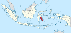
 Location of Southeast Sulawesi in Indonesia | |
| Coordinates: 3°57′00″S 122°30′00″E / 3.95000°S 122.50000°E | |
| Founded | 27 April 1964 |
| Capital and largest city | Kendari |
| Government | |
| • Body | Southeast Sulawesi Provincial Government |
| • Governor | Andap Budhi Revianto (Acting) |
| • Vice Governor | Vacant |
| Area | |
| • Total | 38,430.84 km2 (14,838.23 sq mi) |
| • Rank | 24th in Indonesia |
| Highest elevation | 2,650 m (8,694 ft) |
| Population (mid 2023 estimate)[1] | |
| • Total | 2,743,574 |
| • Density | 71/km2 (180/sq mi) |
| Demographics | |
| • Ethnic groups | 36% Tolaki 26% Butonese 19% Muna 10% Moronene 5.2% Wawonii 3.5% Chinese 0.3% other |
| • Religion | 96% Islam 2.3% Christianity 1.1% Hinduism 0.4% Buddhism |
| • Languages | Indonesian (official) Buginese (lingua franca) Cia-Cia, Moronene, Muna, Tolaki, Wakatobi, Wolio (regional) |
| Time zone | UTC+08 (Indonesia Central Time) |
| GDP (nominal) | 2022 |
| - Total | Rp 158,761 billion (23rd) US$ 10.69 billion US$ 33.36 billion (PPP) |
| - Per capita | Rp 58.76 million (19th) US$ 3,958 US$ 12,350 (PPP) |
| - Growth | |
| HDI | |
| HDI rank | 17th (2023) |
| Website | sultraprov.go.id |
Southeast Sulawesi (Indonesian: Sulawesi Tenggara, often abbreviated to Sultra), is a province on the island of Sulawesi, forming the southeastern peninsula of that island, together with a number of substantial offshore islands such as Buton, Muna, Kabaena and Wawonii (formerly called Wowoni), together with many smaller islands. It is bordered by South Sulawesi and Central Sulawesi to the north, sharing a maritime border with Maluku and North Maluku to the east and East Nusa Tenggara to the south, as well a very narrow maritime border with East Timor to the south. The capital is the city of Kendari, on the east coast of the peninsula.
The province has no highway road connecting to the rest of the island, and the primary transportation link is a ferry across the Bone Gulf between Watampone (Bone) in South Sulawesi and the port of Kolaka in Southeast Sulawesi.
- ^ Badan Pusat Statistik, Jakarta, 28 February 2024, Provinsi Sulawesi Tenggara Dalam Angka 2024 (Katalog-BPS 1102001.74)
© MMXXIII Rich X Search. We shall prevail. All rights reserved. Rich X Search

