Back Suiddistrik, Botswana Afrikaans المقاطعة الجنوبية Arabic Distritu Sur (Botsuana) AST Паўднёвая акруга (Батсвана) Byelorussian Паўднёвая акруга (Батсвана) BE-X-OLD Южен окръг Bulgarian Southern (Botswana) Breton Southern District (distrito sa Botswana) CEB Southern District German Νότια Περιφέρεια (Μποτσουάνα) Greek
This article needs additional citations for verification. (November 2019) |
Southern | |
|---|---|
 | |
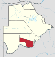
 Location within Botswana | |
| Coordinates: 25°00′S 25°00′E / 25.000°S 25.000°E | |
| Country | |
| Capital | Kanye |
| Area | |
| • Total | 28,470 km2 (10,990 sq mi) |
| Population (2022 census)https://www.statsbots.org.bw | |
| • Total | 140,296 |
| • Density | 4.9/km2 (13/sq mi) |
| Time zone | UTC+2 (Central Africa Time) |
| HDI (2017) | 0.700[1] high · 5th |
Southern is one of the districts of Botswana. The capital of Southern district is Kanye, home to the Bangwaketse and Barolong in Botswana. The Southern district is home to Botswana's second largest beef farmers where there are large privately owned ranges, and several government run beef ranges which provide agricultural support to the local farmers. Maize and sorghum, Botswana's staple crop, are also raised in the area. Southern district is where the third diamond mine of Botswana was found (the Jwaneng diamond mine), which buoys Botswana's economic state of prosperity. It was the first district to house the capital city before being moved to Gaborone after independence.
In the south, Southern borders the North West Province of South Africa. Domestically, it borders South-East District in east, Kweneng District in north, Kgalagadi District and south west.
As of 2011, the total population of the district was 197,767 compared to 171,652 in 2001. The growth rate of population during the decade was 1.43. The total number of workers constituted 51,187 with 29,043 males and 22,141 females, with a majority involved in agriculture. The district is administered by a district administration and district council which are responsible for local administration.
- ^ "Sub-national HDI - Area Database - Global Data Lab". hdi.globaldatalab.org. Retrieved 2018-09-13.
© MMXXIII Rich X Search. We shall prevail. All rights reserved. Rich X Search