Back سبرينغفيلد (أوهايو) Arabic سبرينجفيلد (اوهايو) ARZ اسپرینقفیلد، اوهایو AZB Спрингфийлд (Охайо) Bulgarian སི་པི་རིང་ཧྥིལ་ཌི། (ཨོ་ཧེའོ།) Tibetan Springfield (Ohio) Catalan Спрингфилд (Огайо) CE Springfield (kapital sa kondado sa Tinipong Bansa, Ohio) CEB Springfield (Ohio) Czech Springfield, Ohio Welsh
Springfield, Ohio | |
|---|---|
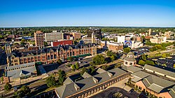
 Skyline view of downtown Springfield | |
| Nickname(s): The Home City, The Rose City (City of Roses), The Champion City, The Field | |
 Interactive map of Springfield | |
| Coordinates: 39°55′12″N 83°46′15″W / 39.92000°N 83.77083°W | |
| Country | |
| State | |
| County | Clark |
| Founded | 1801 |
| Incorporated | 1827 (village) |
| Government | |
| • Type | Council–manager[1] |
| • Mayor | Rob Rue |
| Area | |
| • City | 26.36 sq mi (68.27 km2) |
| • Land | 26.16 sq mi (67.75 km2) |
| • Water | 0.20 sq mi (0.52 km2) |
| Elevation | 929 ft (283 m) |
| Population (2020) | |
| • City | 58,662 |
| • Density | 2,242.52/sq mi (865.86/km2) |
| • Metro | 136,001 |
| Time zone | UTC−5 (EST) |
| • Summer (DST) | UTC−4 (EDT) |
| ZIP Codes | 45501–45506 |
| Area code(s) | 937, 326 |
| FIPS code | 39-74118[4] |
| GNIS feature ID | 1085859[3] |
| Website | www.ci.springfield.oh.us |
Springfield is a city in and the county seat of Clark County, Ohio, United States.[5] The municipality is located in southwestern Ohio and is situated on the Mad River, Buck Creek, and Beaver Creek, approximately 45 miles (72 km) west of Columbus and 25 miles (40 km) northeast of Dayton. As of the 2020 census, the city had a total population of 58,662, while the Springfield metropolitan area had a population of 136,001 residents.
Springfield is home to Wittenberg University, a liberal arts college. The Little Miami Scenic Trail, a paved rail-trail that is nearly 80 miles long, extends from the Buck Creek Scenic Trail head in Springfield south to Newtown, Ohio. In 1983, Newsweek magazine featured Springfield in its 50th-anniversary issue, entitled, "The American Dream." It chronicled the effects of changes of the previous 50 years on five local families. In 2004, Springfield was chosen as an "All-America City." In the 2010s, Springfield ranked low among cities in the state and nation for indicators such as health, happiness, and well-being.[6][7][8][9]
- ^ "Government". City of Springfield, Ohio. Retrieved December 18, 2019.
- ^ "ArcGIS REST Services Directory". United States Census Bureau. Retrieved September 20, 2022.
- ^ a b U.S. Geological Survey Geographic Names Information System: Springfield, Ohio
- ^ "U.S. Census website". United States Census Bureau. Retrieved January 31, 2008.
- ^ "Find a County". National Association of Counties. Retrieved June 7, 2011.
- ^ "Springfield third worst in wellness survey". Springfield News-Sun. May 14, 2011.
- ^ Martin, Patrick (October 14, 2012). "Welcome to Springfield, Ohio, the 'unhappiest city' in the U.S." The Globe and Mail. Retrieved October 25, 2017.
- ^ Michael Cooper. "Springfield ranked least healthy city in Ohio by national report". Springfield News-Sun. Retrieved December 2, 2012.
- ^ "The Least Healthy City in Every State". 24/7 Wall St. Retrieved September 10, 2015.
© MMXXIII Rich X Search. We shall prevail. All rights reserved. Rich X Search


