Back Springfield Township (Montgomery County, Pennsylvania) German Municipio de Springfield (condado de Montgomery, Pensilvania) Spanish اسپرینگفیلد تاونشیپ، شهرستان مونتگومری، پنسیلوانیا Persian Springfield Township (comté de Montgomery, Pennsylvanie) French Спрінгфілд Тауншип (округ Монтгомері, Пенсільванія) Ukrainian Xã Springfield, Quận Montgomery, Pennsylvania Vietnamese
Springfield Township | |
|---|---|
 | |
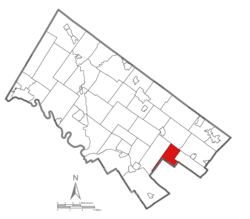
 Location of Springfield Township in Montgomery County, Pennsylvania | |
| Coordinates: 40°05′30″N 75°11′59″W / 40.09167°N 75.19972°W | |
| Country | United States |
| State | Pennsylvania |
| County | Montgomery |
| Established | 1681 |
| Area | |
| • Total | 6.79 sq mi (17.6 km2) |
| • Land | 6.78 sq mi (17.6 km2) |
| • Water | 0.01 sq mi (0.03 km2) |
| Elevation | 276 ft (84 m) |
| Population (2010) | |
| • Total | 19,418 |
| • Estimate (2016)[2] | 19,685 |
| • Density | 2,900/sq mi (1,100/km2) |
| Time zone | UTC-5 (EST) |
| • Summer (DST) | UTC-4 (EDT) |
| Area code(s) | 215, 267, and 445 |
| FIPS code | 42-091-73088 |
| Website | www |
Springfield Township is a township in Montgomery County, Pennsylvania. The population was 20,993 in 2022 according the Census Bureau. It includes the villages of Wyndmoor, Erdenheim, Flourtown, and Oreland. The communities of Lafayette Hill, Fort Washington, Laverock, North Hills, Miquon, and Glenside are also situated partly inside the Township.
- ^ "2016 U.S. Gazetteer Files". United States Census Bureau. Retrieved Aug 14, 2017.
- ^ "Population and Housing Unit Estimates". Retrieved June 9, 2017.
© MMXXIII Rich X Search. We shall prevail. All rights reserved. Rich X Search

