Back Stanegate Catalan Stanegate Czech Stanegate German Stanegate Spanish استنگیت Persian Stanegate French Stanegate Italian Stanegate NN Stanegate NB
This article needs additional citations for verification. (June 2022) |
| Stanegate | |
|---|---|
| Roman Road | |
 Route of the Stanegate | |
| Route information | |
| Length | 38 mi (61 km) |
| Time period | Roman Britain |
| Margary number | 85 |
| Major junctions | |
| From | Corstopitum |
| Vindolanda, Magnis | |
| To | Luguvalium |
| Location | |
| Country | United Kingdom |
| Road network | |

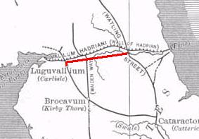
The Stanegate (meaning "stone road" in Northumbrian dialect[1]) was an important Roman road and early frontier built in what is now northern England. It linked many forts including two that guarded important river crossings: Corstopitum (Corbridge) on the River Tyne in the east (situated on Dere Street) and Luguvalium (Carlisle) (on the River Eden) in the west. The Stanegate ran through the natural gap formed by the valleys of the River Tyne in Northumberland and the River Irthing in Cumbria. It predated the Hadrian's Wall frontier by several decades; the Wall would later follow a similar route, albeit slightly to the north.
The Stanegate should not be confused with the two Roman roads called Stane Street in the south of England, namely Stane Street (Chichester) and Stane Street (Colchester). In both these cases the meaning is the same as for the northern version, indicating a stone or paved road.
The Stanegate differed from most other Roman roads in that it often followed the easiest gradients, and so tended to weave around, whereas typical Roman roads follow a straight path, even if this sometimes involves having punishing gradients to climb.[2]
A large section of the Stanegate is still in use today as a modern minor road between Fourstones and Vindolanda in Northumberland.
- ^ Northumberland Words - A Glossary of Words Used in the County of Northumberland and on the Tyneside -, Volume 2, Richard Oliver Heslop, Read Books, 2008, 1409765261, 9781409765264, page. 696
- ^ Raymond Selkirk (1995). On The Trail of the Legions (pages 107–120). Anglia Publishing. ISBN 1-897874-08-1.
© MMXXIII Rich X Search. We shall prevail. All rights reserved. Rich X Search