Back Stavoren CEB Stavoren German Stavoren Esperanto استافورن Persian Stavoren French Starum Frisian Stavoren Italian Stavoren Kurdish Stavoren NDS Stavoren NDS-NL
Stavoren
West Frisian: Starum | |
|---|---|
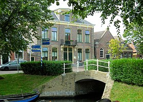
 City centre | |
 Map of Stavoren (2019) | |
| Coordinates: 52°53′N 5°22′E / 52.883°N 5.367°E | |
| Country | Netherlands |
| Province | Friesland |
| Municipality | Súdwest-Fryslân |
| Population (2017) | |
| • Total | 950 |
| Time zone | UTC+1 (CET) |
| • Summer (DST) | UTC+2 (CEST) |
| Postal code | 8715 |
| Telephone area | 0514 |
Stavoren (Dutch pronunciation: [ˈstaːvərə(n)]; West Frisian: Starum; previously Staveren) is a city in the province of Friesland, Netherlands, on the coast of the IJsselmeer, about 5 km (3.1 mi) south of Hindeloopen, in the municipality of Súdwest-Fryslân.
Stavoren had a population of 950 in January 2017.[1] It is one of the stops on the Elfstedentocht (English: "eleven cities tour"), an ice skating contest that occurs when the winter temperatures provide safe conditions. A ferry for pedestrians and cyclists operates between Stavoren and Enkhuizen, with increased frequency during summer months. The Friese Kustpad, a 131 kilometres (81 miles) long-distance trail to Lauwersoog, begins in Stavoren.
- ^ Kerncijfers wijken en buurten 2017 Archived 2018-08-13 at the Wayback Machine on CBS Statline.
© MMXXIII Rich X Search. We shall prevail. All rights reserved. Rich X Search


