Back مقاطعة ستيرلنغ (تكساس) Arabic Sterling County, Texas BAR Стэрлінг (акруга, Тэхас) Byelorussian Стърлинг (окръг, Тексас) Bulgarian স্টের্লিং কাউন্টি, টেক্সাস BPY Sterling Gông (Texas) CDO Sterling County CEB Sterling County Czech Sterling County, Texas Welsh Sterling County German
Sterling County | |
|---|---|
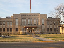
 Sterling County Court House off U.S. Highway 87 in Sterling City | |
 Location within the U.S. state of Texas | |
 Texas's location within the U.S. | |
| Coordinates: 31°49′N 101°03′W / 31.82°N 101.05°W | |
| Country | |
| State | |
| Founded | 1891 |
| Named for | W. S. Sterling, an early settler |
| Seat | Sterling City |
| Largest city | Sterling City |
| Area | |
| • Total | 924 sq mi (2,390 km2) |
| • Land | 923 sq mi (2,390 km2) |
| • Water | 0.1 sq mi (0.3 km2) 0.01% |
| Population (2020) | |
| • Total | 1,372 |
| • Density | 1.5/sq mi (0.57/km2) |
| Time zone | UTC−6 (Central) |
| • Summer (DST) | UTC−5 (CDT) |
| Congressional district | 11th |
| Website | www |
Sterling County is a county located on the Edwards Plateau in the U.S. state of Texas. As of the 2020 census, its population was 1,372,[1] making it the ninth-least populous county in Texas. Its county seat is Sterling City.[2] The county is named for W. S. Sterling, an early settler in the area. Sterling County was one of 30 prohibition, or entirely dry, counties in the state of Texas, but is now a moist county.[3]
- ^ "Sterling County, Texas". United States Census Bureau. Retrieved February 23, 2021.
- ^ "Find a County". National Association of Counties. Retrieved June 7, 2011.
- ^ "Wet/Dry Status of Texas Counties". Texas Alcoholic Beverage Commission. Retrieved July 27, 2018.
© MMXXIII Rich X Search. We shall prevail. All rights reserved. Rich X Search