Back ستوكتون (يوتا) Arabic ستوكتون ARZ ایستوکتون، یوتا AZB Stockton (Utah) Catalan Стоктон (Юта) CE Stockton (lungsod sa Tinipong Bansa, Utah) CEB Stockton, Utah Welsh Stockton (Utah) Spanish Stockton (Utah) Basque استاکتون، یوتا Persian
Stockton, Utah | |
|---|---|
 Main Street in winter | |
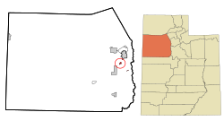
 Location in Tooele County and the state of Utah | |
 Location of Utah in the United States | |
| Coordinates: 40°27′4″N 112°21′43″W / 40.45111°N 112.36194°W | |
| Country | United States |
| State | Utah |
| County | Tooele |
| Settled | 1863[1] |
| Incorporated | 1901 |
| Named for | Stockton, California[2] |
| Government | |
| • Type | Mayor/Council |
| • Mayor | Nando Meli |
| Area | |
| • Total | 1.69 sq mi (4.38 km2) |
| • Land | 1.68 sq mi (4.36 km2) |
| • Water | 0.01 sq mi (0.02 km2) |
| Elevation | 5,118 ft (1,560 m) |
| Population (2010) | |
| • Total | 616 |
| • Estimate (2019)[4] | 682 |
| • Density | 405.23/sq mi (156.46/km2) |
| Time zone | UTC-7 (Mountain (MST)) |
| • Summer (DST) | UTC-6 (MDT) |
| ZIP code | 84071 |
| Area code | 435 |
| FIPS code | 49-73050[5] |
| GNIS feature ID | 1432990[6] |
| Website | www.stocktontown.org |
Stockton is a town in Tooele County, Utah, United States. It is part of the Salt Lake City, Utah Metropolitan Statistical Area. The population was 616 at the 2010 census.
- ^ Town website (the town is gearing to celebrate the sesquicentennial of its settlement in January 2013)
- ^ The 3rd Regiment of California Volunteers, commanded by Col. Connor, had been organized in Stockton, California.
- ^ "2019 U.S. Gazetteer Files". United States Census Bureau. Retrieved August 7, 2020.
- ^ Cite error: The named reference
USCensusEst2019CenPopScriptOnlyDirtyFixDoNotUsewas invoked but never defined (see the help page). - ^ "U.S. Census website". United States Census Bureau. Retrieved January 31, 2008.
- ^ "US Board on Geographic Names". United States Geological Survey. October 25, 2007. Retrieved January 31, 2008.
© MMXXIII Rich X Search. We shall prevail. All rights reserved. Rich X Search