Back مقاطعة ستودارد (ميزوري) Arabic Stoddard County, Missouri BAR Стодърд (окръг, Мисури) Bulgarian স্টোডার্ড কাউন্টি, মিসৌরি BPY Stoddard Gông (Missouri) CDO Стоддард (гуо, Миссури) CE Stoddard County CEB Stoddard County, Missouri Welsh Stoddard County German Condado de Stoddard Spanish
Stoddard County | |
|---|---|
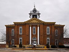
 The Stoddard County Courthouse in Bloomfield | |
 Location within the U.S. state of Missouri | |
 Missouri's location within the U.S. | |
| Coordinates: 36°52′N 89°57′W / 36.86°N 89.95°W | |
| Country | |
| State | |
| Founded | January 2, 1835 |
| Named for | Amos Stoddard |
| Seat | Bloomfield |
| Largest city | Dexter |
| Area | |
| • Total | 829 sq mi (2,150 km2) |
| • Land | 823 sq mi (2,130 km2) |
| • Water | 5.8 sq mi (15 km2) 0.7% |
| Population (2020) | |
| • Total | 28,672 |
| • Density | 35/sq mi (13/km2) |
| Time zone | UTC−6 (Central) |
| • Summer (DST) | UTC−5 (CDT) |
| Congressional district | 8th |
Stoddard County is a county located in the southeastern portion of the U.S. state of Missouri. As of the 2020 census, the population was 28,672.[1] The county seat is Bloomfield.[2] The county was officially organized on January 2, 1835, and is named for Amos Stoddard, the first American commandant (an early term for "governor") of Upper Louisiana.[3]
- ^ Cite error: The named reference
2020 censuswas invoked but never defined (see the help page). - ^ "Find a County". National Association of Counties. Archived from the original on May 31, 2011. Retrieved June 7, 2011.
- ^ Eaton, David Wolfe (1918). How Missouri Counties, Towns and Streams Were Named. The State Historical Society of Missouri. p. 366.
© MMXXIII Rich X Search. We shall prevail. All rights reserved. Rich X Search