Back صغد Arabic Soqd vilayəti Azerbaijani Сагдыйская вобласць Byelorussian Согдийска област Bulgarian Província de Sughd Catalan Согдан регион CE Viloyati Sughd CEB Sogdijský vilájet Czech Sughd German Soğd DIQ
Sughd Province
Вилояти Суғд (in Tajik) Согдийская область (in Russian) | |
|---|---|
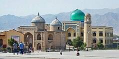
From the top to bottom-right, Khujand, Panjakent District, Rudaki's Tomb, Ayni District, Yaghnob River | |
 Sughd in Tajikistan | |
| Coordinates: 39°30′N 69°0′E / 39.500°N 69.000°E | |
| Country | |
| Capital | Khujand |
| Area | |
| • Total | 25,200 km2 (9,700 sq mi) |
| Population (2020)[1] | |
| • Total | 2,707,300 |
| • Density | 110/km2 (280/sq mi) |
| ISO 3166 code | TJ-SU |
| HDI (2017) | 0.659[2] medium |
| Official languages | |
Sughd Province (Tajik: Вилояти Суғд, romanized: Viloyati Sughd, lit. 'Sogdia Region'; Persian: ولایت سُغْد) is one of the four administrative divisions and one of the three provinces (Tajik: вилоятҳо, romanized: viloyatho; Persian: ولایت) that make up Tajikistan. Centered in the historical Sogdiana, it is located in the northwest of the country, with an area of some 25,400 square kilometers and a population of 2,707,300 (2020 estimate),[1] up from 2,233,550 according to the 2010 census and 1,871,979 in 2000. The capital is Khujand. The Province's ethnic composition in 2010 was 84% Tajik, 14.8% Uzbek, 0.6% Kyrgyz, 0.4% Russian and 0.1% Tatar.[4]
The province shares a border with the Jizzakh, Namangan, Samarkand and Fergana regions of Uzbekistan, and the Osh and Batken regions of Kyrgyzstan. The Syr Darya river flows through it. It contains the Akash Massif and Mogoltau Massif Important Bird Areas. Sughd is separated from the rest of Tajikistan by the Gissar Range (passes may be closed in winter). The southern part of the region is the east-west valley of the upper Zarafshan River. North, over the Turkestan Range, is the Ferghana Valley. The region has 29% of Tajikistan's population[1] and one-third of its arable land.[5] It produces two-thirds of the country's GDP.[6]
- ^ a b c "Population of the Republic of Tajikistan as of 1 January 2020" (PDF) (in Russian). Statistics office of Tajikistan. Retrieved 2 October 2020.
- ^ "Sub-national HDI - Area Database - Global Data Lab". hdi.globaldatalab.org. Retrieved 2018-09-13.
- ^ "КОНСТИТУЦИЯ РЕСПУБЛИКИ ТАДЖИКИСТАН". prokuratura.tj. Parliament of Tajikistan. Retrieved 9 January 2020.
- ^ "CensusInfo - Data". www.censusinfo.tj. Retrieved 2019-09-09.
- ^ Agriculture of the Republic of Tajikistan, statistical yearbook,State Statistical Committee, Dushanbe, 2008
- ^ Robert Middleton and Huw Thomas, 'Tajikistan and the High Pamirs', Odyssey Books, 2008, page 166
© MMXXIII Rich X Search. We shall prevail. All rights reserved. Rich X Search


