Back مقاطعة سوليفان (ميزوري) Arabic Sullivan County, Missouri BAR Съливан (окръг, Мисури) Bulgarian সুল্লিভান কাউন্টি, মিসৌরি BPY Sullivan Gông (Missouri) CDO Салливан (гуо, Миссури) CE Sullivan County (kondado sa Tinipong Bansa, Missouri) CEB Sullivan County, Missouri Welsh Sullivan County (Missouri) German Κομητεία Σάλιβαν (Μιζούρι) Greek
Sullivan County | |
|---|---|
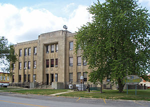
 Sullivan County Courthouse in Milan | |
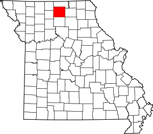
 Location within the U.S. state of Missouri | |
 Missouri's location within the U.S. | |
| Coordinates: 40°13′N 93°07′W / 40.21°N 93.11°W | |
| Country | |
| State | |
| Founded | 1843 (created) 1845 (organized) |
| Named for | John Sullivan |
| Seat | Milan |
| Largest city | Milan |
| Area | |
| • Total | 652 sq mi (1,690 km2) |
| • Land | 648 sq mi (1,680 km2) |
| • Water | 3.5 sq mi (9 km2) 0.5% |
| Population (2020) | |
| • Total | 5,999 |
| • Density | 9.2/sq mi (3.6/km2) |
| Time zone | UTC−6 (Central) |
| • Summer (DST) | UTC−5 (CDT) |
| Congressional district | 6th |
Sullivan County is a county located in the northern portion of the U.S. state of Missouri. As of the 2020 census, the population was 5,999.[1] Its county seat is Milan.[2] The county was organized February 14, 1845, and named for Major General John Sullivan of the American Revolutionary War.[3]
- ^ "Explore Census Data". data.census.gov. Retrieved December 20, 2021.
- ^ "Find a County". National Association of Counties. Retrieved June 7, 2011.
- ^ Eaton, David Wolfe (1917). How Missouri Counties, Towns and Streams Were Named. The State Historical Society of Missouri. p. 68.
© MMXXIII Rich X Search. We shall prevail. All rights reserved. Rich X Search