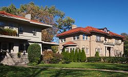
Historic Hill District | |
 The Cathedral of St. Paul overshadows mansions on east Summit Avenue | |
| Location | Irregular pattern from Pleasant and Grand Aves. to Holly and Marshall Aves., from Lexington Pkwy. to 4th and Pleasant in St. Paul, Minnesota |
|---|---|
| Built | 1860 |
| Architect | Multiple |
| Architectural style | Late 19th and 20th Century Revivals, Late Victorian |
| NRHP reference No. | 76001067[1] |
| Added to NRHP | August 13, 1976 |
West Summit Avenue Historic District | |
 Homes on West Summit Avenue | |
| Location | Summit Avenue between Lexington Parkway and Mississippi River Boulevard in St. Paul, Minnesota |
|---|---|
| Built | 1887 |
| Architect | Multiple |
| Architectural style | Colonial Revival, Classical Revival, Bungalow/Craftsman Queen Anne Romanesque Revival Beaux-Arts Tudor Revival |
| NRHP reference No. | 93000332[1] |
| Added to NRHP | May 4, 1993 |
Summit Avenue is a street in St. Paul, Minnesota, United States, known for being the longest avenue of Victorian homes in the country, having a number of historic houses, churches, synagogues, and schools. The street starts just west of downtown St. Paul and continues four and a half miles west to the Mississippi River where Saint Paul meets Minneapolis. Other cities have similar streets, such as Prairie Avenue in Chicago, Euclid Avenue in Cleveland, and Fifth Avenue in New York City. Summit Avenue is notable for having preserved its historic character and mix of buildings, as compared to these other examples. Historian Ernest R. Sandeen described Summit Avenue as "the best preserved example of the Victorian monumental residential boulevard."[2]
Summit Avenue is part of two National Historic Districts and two City of Saint Paul Heritage Preservation Districts. The National Historic Districts are the Historic Hill District, an irregular area roughly bounded by Lexington Avenue, Portland Avenue, Dale Street North, Marshall Avenue, Pleasant Street, and Grand Avenue[3] (exclusive of the area within the Woodland Park Historic District), and the West Summit Avenue Historic District, a narrow area running from Oxford Street South west to the Mississippi River along Summit Avenue.[4][1][5] The city districts are Summit Hill, also known as Crocus Hill, a triangular region from Lexington Avenue on the west, Summit Avenue on the north, and the bluffs (just north of Interstate Highway 35E) on the south, and Ramsey Hill, the area bounded by Summit Avenue, Dale Street, Interstate Highway 94, and a line running north from the Cathedral of St. Paul.[5][6] Most of the houses in this district are large, distinctive houses built between 1890 and 1920.
Summit Avenue was named one of 10 "great streets" nationally by the American Planning Association in 2008.[7]
- ^ a b c "National Register Information System". National Register of Historic Places. National Park Service. January 23, 2007.
- ^ Sandeen p. 1
- ^ Charles W. Nelson; Susan Zeik (June 7, 1976). "National Register of Historic Places Inventory/Nomination: Historic Hill District". National Park Service. Retrieved August 3, 2019. With accompanying 203 photos from 1976-89
- ^ Norene A. Roberts; Jeanne M. Zimniewicz (March 1992). "National Register of Historic Places Registration: West Summit Avenue Historic District". National Park Service. Retrieved August 3, 2019. With accompanying 91 photos
- ^ a b "resources & links". Summit Avenue Residential Preservation Association. Retrieved 2008-04-10.
- ^ Millett p. 436
- ^ "Summit Avenue: St. Paul, Minnesota". American Planning Association.
© MMXXIII Rich X Search. We shall prevail. All rights reserved. Rich X Search


