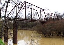
The Sunflower River (also known as the Big Sunflower River) is one of the main tributaries of the Yazoo River in the U.S. state of Mississippi. It is navigable by barge for 50 miles. It rises in DeSoto County, Mississippi near the Tennessee border and flows south for 100 miles to the Yazoo River, a major tributary of the Mississippi River. At Clarksdale, the county seat of Coahoma County, the annual Sunflower River Blues & Gospel Festival is held.
The United States Army Corps of Engineers maintains a navigation channel, thirty miles in length. Built in 1976, the channel is used by barges and pleasure craft.
According to the USGS, variant names include Hushpuckaman Creek.[1][2] The Hushpuckena River drains the northwestern part of the Sunflower River Basin, Quiver River drains the northeastern portion, and Bogue Phalia drains the west central portion of the watershed, all of which lies in the alluvium soil of the Yazoo Delta.[3] At Sunflower, Mississippi, the river flow measures approximately 1,099 cubic feet per second.[4]
- ^ U.S. Geological Survey Geographic Names Information System: Big Sunflower River
- ^ La Tourette, John. An Accurate Map or Delineation of the State of Mississippi, with a Large Portion of Alabama and Louisiana. Mobile, Alabama, 1839; and Map of the State of Alabama and West Florida. Montgomery, Alabama, 1856.
- ^ Speers, Paul et al. (1964). "Low-Flow Characteristics of Streams in the Miss Embayment in Miss. and Ala.: Water Resources of the Mississippi Embayment." Geological Survey Professional Paper 448-1. Washington: GPO. pp. I-29
- ^ "USGS Surface Water data for Mississippi: USGS Surface-Water Annual Statistics".
© MMXXIII Rich X Search. We shall prevail. All rights reserved. Rich X Search
