Sutherland | |
|---|---|
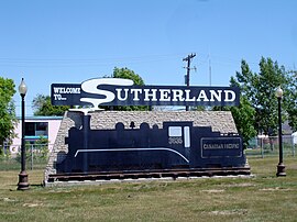
 Sutherland entrance sign | |
 Sutherland location map | |
| Coordinates: 52°8′12″N 106°36′14″W / 52.13667°N 106.60389°W | |
| Country | Canada |
| Province | Saskatchewan |
| City | Saskatoon |
| Suburban Development Area | University Heights |
| Neighbourhood | Sutherland |
| Settled | 1908 |
| Incorporated (town) | 1912 |
| Annexed | 1956 |
| Government | |
| • Type | Municipal (Ward 1) |
| • Administrative body | Saskatoon City Council |
| • Councillor | Darren Hill |
| • Member of Legislature (MLA) | Paul Merriman (SKP) |
| • Member of Parliament (MP) | Corey Tochor (CON) |
| Area | |
| • Total | 2.14 km2 (0.83 sq mi) |
| Population (2006) | |
| • Total | 5,206 |
| • Average Income | $51,857 |
| Time zone | UTC-6 (UTC) |
| Website | Sutherland-Forest Grove Community Association |
| List of neighbourhoods in Saskatoon | |
Sutherland is a mostly residential neighbourhood located in east-central Saskatoon, Saskatchewan, Canada. It is an older suburban subdivision, composed of a near-even mix of single-family detached houses and multiple-unit apartment and semi-detached dwellings. As of 2006, the area was home to 5,206 residents. The neighbourhood is a middle-income area, with an average family income of $51,857, an average dwelling value of $204,213 and a home ownership rate of 43.8%.[1][2] According to MLS data, the average sale price of a home as of 2013 was $288,651.[3] Sutherland was administered as a separate town outside of Saskatoon before being annexed by the city in 1956.
- ^ "Sutherland neighbourhood profile - 2007" (PDF). City of Saskatoon. 2007. Retrieved 2007-10-22. [dead link]
- ^ "Populace Spring 2006" (PDF). City of Saskatoon. 2006. Archived from the original (PDF) on 2007-12-01. Retrieved 2007-10-22.
- ^ "Sutherland". Saskatoon Realty. Retrieved 2014-01-08.
© MMXXIII Rich X Search. We shall prevail. All rights reserved. Rich X Search
