Back سوآل میدوز، کالیفورنیا AZB Сволл-Медоус (Калифорни) CE Swall Meadows CEB Swall Meadows (California) Spanish Swall Meadows (Kalifornia) Basque سوآل میدوز، کالیفرنیا Persian Swall Meadows French Swall Meadows (Kalifornija) Croatian Swall Meadows Italian Swall Meadows (California) LLD
Swall Meadows, California | |
|---|---|
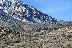
 Top end of Swall Meadows (center), below the Wheeler Crest | |
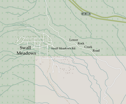
 Street map | |
| Coordinates: 37°30′22″N 118°38′34″W / 37.50611°N 118.64278°W | |
| Country | United States |
| State | California |
| County | Mono |
| Area | |
| • Total | 4.462 sq mi (11.556 km2) |
| • Land | 4.462 sq mi (11.556 km2) |
| • Water | 0 sq mi (0 km2) 0% |
| Elevation | 6,558 ft (1,999 m) |
| Population (2020)[3] | |
| • Total | 178 |
| • Density | 40/sq mi (15/km2) |
| Time zone | UTC-8 (Pacific (PST)) |
| • Summer (DST) | UTC-7 (PDT) |
| ZIP Code | 93514 |
| Area codes | 442/760 |
| FIPS code | 06-77430 |
| GNIS feature IDs | 2583158, 2583158 |
| U.S. Geological Survey Geographic Names Information System: Swall Meadows, California | |
Swall Meadows is an unincorporated community and census-designated place (CDP)[2] in southern Mono County, California, United States. The population was 178 as of the 2020 census.[3] The community is residential, including second homes and a volunteer fire department, but no commercial development. The ZIP Code is 93514.[4] The community is inside area code 760.
- ^ "2022 U.S. Gazetteer Files: California". United States Census Bureau. Retrieved November 8, 2022.
- ^ a b "Swall Meadows Census Designated Place". Geographic Names Information System. United States Geological Survey, United States Department of the Interior. Retrieved January 4, 2015.
- ^ a b "P1. Race – Swall Meadows CDP, California: 2020 DEC Redistricting Data (PL 94-171)". U.S. Census Bureau. Retrieved November 8, 2022.
- ^ "USPS.com – ZIP Code Lookup". usps.com. Retrieved 21 September 2015.
© MMXXIII Rich X Search. We shall prevail. All rights reserved. Rich X Search

