Back جبال الساحل السوري Arabic Ənsariyyə dağları Azerbaijani Ансария Bulgarian Jabal Bahra Catalan Dschebel Ansariye German Cordillera litoral de Siria Spanish Montagnes des Alaouites French הרי אנסריה HE Catena Costiera Siriana Italian Crëps de An-Nusayriyah LLD
| Syrian Coastal Mountain Range | |
|---|---|
| سلسلة الجبال الساحلية | |
 Coastal Mountain Range | |
| Highest point | |
| Peak | Nabi Yunis |
| Elevation | 1,562 m (5,125 ft) |
| Dimensions | |
| Length | 150 km (93 mi) |
| Geography | |
| Location | Syria |
| Range coordinates | 35°36′N 36°14′E / 35.60°N 36.24°E |
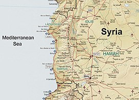
The Coastal Mountain Range (Arabic: سلسلة الجبال الساحلية, Silsilat al-Jibāl as-Sāḥilīyah) also called Jabal al-Ansariya, Jabal an-Nusayria or Jabal al-`Alawīyin (Ansari, Nusayri or Alawi Mountains) is a mountain range in northwestern Syria running north–south, parallel to the coastal plain.[1] The mountains have an average width of 32 kilometres (20 mi), and their average peak elevation is just over 1,200 metres (3,900 ft) with the highest peak, Nabi Yunis, reaching 1,562 metres (5,125 ft), east of Latakia.[1] In the north the average height declines to 900 metres (3,000 ft), and to 600 metres (2,000 ft) in the south.
This mountain range has been home to an Alawite population since the Middle Ages.[2]
- ^ a b Federal Research Division, Library of Congress (2005) "Country Profile: Syria" (PDF), page 5.
- ^ Cite error: The named reference
:0was invoked but never defined (see the help page).
© MMXXIII Rich X Search. We shall prevail. All rights reserved. Rich X Search