Back Tarangnan BCL Tarangnan CBK-ZAM Tarangnan CEB Tarangnan German Tarangnan French Tarangnan ID Tarangnan ILO Tarangnan Italian ტარანგნანი Georgian Tarangnan Malay
Tarangnan | |
|---|---|
| Municipality of Tarangnan | |
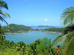
 Mountain-top view of Tarangnan | |
 Map of Samar with Tarangnan highlighted | |
Location within the Philippines | |
| Coordinates: 11°54′N 124°45′E / 11.9°N 124.75°E | |
| Country | Philippines |
| Region | Eastern Visayas |
| Province | Samar |
| District | 1st district |
| Founded | April 1, 1884 |
| Barangays | 41 (see Barangays) |
| Government | |
| • Type | Sangguniang Bayan |
| • Mayor | Danilo V. Tan |
| • Vice Mayor | Arnel R. Tan |
| • Representative | Stephen James Tan |
| • Electorate | 19,761 voters (2022) |
| Area | |
| • Total | 132.49 km2 (51.15 sq mi) |
| Elevation | 16 m (52 ft) |
| Highest elevation | 335 m (1,099 ft) |
| Lowest elevation | 0 m (0 ft) |
| Population (2020 census)[3] | |
| • Total | 25,713 |
| • Density | 190/km2 (500/sq mi) |
| • Households | 5,936 |
| Economy | |
| • Income class | 4th municipal income class |
| • Poverty incidence | 33.54 |
| • Revenue | ₱ 132.2 million (2020) |
| • Assets | ₱ 294.2 million (2020) |
| • Expenditure | ₱ 118 million (2020) |
| • Liabilities | ₱ 61.43 million (2020) |
| Service provider | |
| • Electricity | Samar 1 Electric Cooperative (SAMELCO 1) |
| Time zone | UTC+8 (PST) |
| ZIP code | 6704 |
| PSGC | |
| IDD : area code | +63 (0)55 |
| Native languages | Waray Tagalog |
Tarangnan, officially the Municipality of Tarangnan (Waray: Bungto han Tarangnan; Tagalog: Bayan ng Tarangnan), is a 4th class municipality in the province of Samar, Philippines. According to the 2020 census, it has a population of 25,713 people.[3]
Tarangnan is situated on the western coast of Samar Island, to the south-east of the ancient town of Bangahon (now Gandara) and to the north of Samar's capital Catbalogan. Tarangnan is found near the former ancient pueblo Tinago, the first town to be Christianized and was made a center or cabecera.[5]
Tarangnan has its own municipal hospital which was inaugurated in 1982, with a 10-bed capacity. It is augmented by Rural Health Unit extension workers. It has daycare centers which also cater the needs of pre-schoolers.
- ^ Municipality of Tarangnan | (DILG)
- ^ "2015 Census of Population, Report No. 3 – Population, Land Area, and Population Density" (PDF). Philippine Statistics Authority. Quezon City, Philippines. August 2016. ISSN 0117-1453. Archived (PDF) from the original on May 25, 2021. Retrieved July 16, 2021.
- ^ a b Census of Population (2020). "Region VIII (Eastern Visayas)". Total Population by Province, City, Municipality and Barangay. Philippine Statistics Authority. Retrieved 8 July 2021.
- ^ "PSA Releases the 2021 City and Municipal Level Poverty Estimates". Philippine Statistics Authority. 2 April 2024. Retrieved 28 April 2024.
- ^ Kobak, Cantius (2002). Historical Sketches of the Pueblos of Samar and Leyte: 1580-1900. Milwaukee, Wisconsin: Unpublished. p. 721 - 723.
© MMXXIII Rich X Search. We shall prevail. All rights reserved. Rich X Search


