| This is a documentation subpage for Template:Infobox military installation. It may contain usage information, categories and other content that is not part of the original template page. |
| This template uses Lua: |
Usage
| Loring Air Force Base | |||||||||
|---|---|---|---|---|---|---|---|---|---|
Limestone Air Force Base | |||||||||
| Limestone and Caswell, Maine in United States | |||||||||
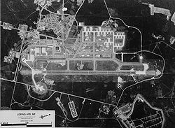
 USGS 1970 Aerial Photo | |||||||||
 Logo of Air Combat Command | |||||||||
| Coordinates | 46°56′59″N 67°53′20″W / 46.94972°N 67.88889°W | ||||||||
| Type | Air Force Base | ||||||||
| Area | 9,000 acres (3,600 ha; 14 sq mi) | ||||||||
| Site information | |||||||||
| Owner | United States Air Force | ||||||||
| Operator | 42nd Bomb Wing | ||||||||
| Open to the public | Yes | ||||||||
| Stations | Caribou Air Force Station (East Loring), Caswell Air Force Station | ||||||||
| Site history | |||||||||
| Built | 1947–1953 | ||||||||
| Built by | United States Army Corps of Engineers | ||||||||
| In use | 1950–1994 | ||||||||
| Fate | Mainly intact, partial demolition | ||||||||
| Events | Cold War | ||||||||
| Garrison information | |||||||||
| Current commander | Robert J. Pavelko | ||||||||
| Garrison | 42nd Bomb Wing | ||||||||
| Occupants | 69th Bombardment Squadron, 70th Bombardment Squadron, 75th Bombardment Squadron, 42d Air Refueling Squadron, 407th Air Refueling Squadron, 2192nd Communications Squadron, 101st Fighter Squadron | ||||||||
| Airfield information | |||||||||
| Identifiers | IATA: KLIZ, ICAO: LIZ | ||||||||
| Elevation | 746 feet (227 m) AMSL | ||||||||
| |||||||||
A military installation infobox may be used to summarize information about a military structure or facility, such as a fortification or military base.
The infobox should be added using the {{Infobox military installation}} template, as shown below:
{{Infobox military installation
| name                   =
| ensign                 =
| ensign_size            =
| native_name            =
| partof                 = <!-- for elements within a larger site -->
| location               =
| nearest_town           = <!-- used in military test site infobox -->
| country                =
| image                  =
| alt                    =
| caption                =
| image2                 = <!--secondary image, major command emblems for airfields -->
| alt2                   =
| caption2               =
| coordinates            = <!-- {{Coord}} -->
| gridref                =
| type                   =
| image_map              =
| image_mapsize          =
| image_map_alt          =
| image_map_caption      =
| pushpin_map            =
| pushpin_mapsize        =
| pushpin_map_alt        =
| pushpin_map_caption    =
| pushpin_relief         =
| pushpin_image          =
| pushpin_label          =
| pushpin_label_position =
| pushpin_mark           =
| pushpin_marksize       =
| code                   = <!--facility/installation code -->
| site_area              = <!-- area of site m2, km2 square mile etc -->
| floor_area             =
| height                 = <!-- height of tallest part, not above sea level -->
| length                 = <!-- for border fences or other DMZs -->
| ownership              = <!-- government department such as the MoD or the United States DoD -->
| operator               = <!-- where different from ownership such as the RAF or the USAF -->
| controlledby           = <!-- such as RAF Bomber Command or the Eighth Air Force -->
| open_to_public         = <!-- for out of use sites/sites with museums etc -->
| condition              =
| site_other_label       = <!-- for renaming "Other facilities" in infobox -->
| site_other             = <!-- for other sorts of facilities – radar types etc -->
| website                =
| built                  = <!-- {{Start date|YYYY}} -->
| built_for              =
| builder                =
| architect              =
| used                   = <!--{{End date|1946}} -->
| materials              =
| fate                   = <!--changed from demolished parameter-->
| demolished             =
| battles                =
| events                 =
| current_commander      = <!-- current commander -->
| past_commanders        = <!-- past notable commander(s) -->
| garrison               = <!-- such as the 25th Bombardment Group -->
| occupants              = <!-- squadrons only -->
| designations           =
| nrhp                   =
| footnotes              = <!-- catchall in case it's needed to preserve something in infobox that doesn't work in new code -->
}}
The following supplemental blocks may be copied into the template above as needed, just prior to the "footnotes" parameter.
Test sites
<!-- begin test site information -->
| subcritical_tests   =
| nuclear_tests       =
| thermonuclear_tests =
| other_tests_label   = <!-- changed from "Other tests" to wording of your choice -->
| other_tests         =
| remediation         =
| image3              =
| alt3                =
| caption3            =
<!--  end test site information  -->
Airfields
<!-- begin airfield information  -->
| IATA                 =
| ICAO                 =
| FAA                  =
| TC                   =
| LID                  =
| GPS                  =
| WMO                  =
| elevation            = <!-- {{Convert| |m|0}} -->
| r1-number            =
| r1-length            = <!-- {{Convert| |m|0}} -->
| r1-surface           =
| h1-number            =
| h1-length            = <!-- {{Convert| |m|0}} -->
| h1-surface           =
| airfield_other_label = <!-- for renaming "Other facilities" in infobox -->
| airfield_other       = <!-- for other sorts of airfield facilities -->
<!--  end airfield information   -->
© MMXXIII Rich X Search. We shall prevail. All rights reserved. Rich X Search

