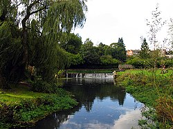
| Tetbury Avon Little Avon | |
|---|---|
 Tetbury Avon near Malmesbury | |
| Etymology | Welsh afon - river |
| Native name | Ingleburn (Old English) |
| Location | |
| Country | England |
| Region | West of England |
| District | Gloucestershire, Wiltshire |
| City | Tetbury, Malmesbury |
| Physical characteristics | |
| Source | Wor Well |
| • location | Tetbury, Gloucestershire, England |
| • coordinates | 51°38′36″N 2°08′33″W / 51.6432°N 2.1424°W |
| • elevation | 375 ft (114 m) |
| Mouth | Bristol Avon |
• location | Malmesbury, Wiltshire, England |
• coordinates | 51°34′56″N 2°05′34″W / 51.5821°N 2.09289°W |
• elevation | 230 ft (70 m) |
| Length | 7 mi (11 km), south easterly |
| Basin size | 28.5 sq mi (74 km2) |
| Discharge | |
| • average | 24.4 cu ft/s (0.69 m3/s) |
| • minimum | 1 cu ft/s (0.028 m3/s) |
| • maximum | 141 cu ft/s (4.0 m3/s) |
| Basin features | |
| Tributaries | |
| • right | Cutwell Brook, Wormwell Brook |
| River system | Bristol Avon |
The Tetbury Avon, also known as the River Avon (Tetbury Branch), Little Avon or Ingleburn (Anglo-Saxon – English river), is a tributary of the Bristol Avon in south-west England. It rises at Tetbury in Gloucestershire and flows in a generally south-easterly direction, joining the Sherston Avon at Malmesbury in Wiltshire.[1] The water flow has been reduced by public water extraction from its source aquifer in the Cotswold Hills. In the past watermills were used for fulling wool and grinding corn; one working mill survives.
- ^ Ordnance Survey 1:25,000 scale Explorer map sheet 168 Stroud, Tetbury & Malmesbury
© MMXXIII Rich X Search. We shall prevail. All rights reserved. Rich X Search
