Back Selva de Teutoburgo AN غابة تويتوبورغ Arabic غابة تويتوبورج ARZ Тевтобургска гора Bulgarian Teutobergienses Saltus Catalan Teutoburger Wald CEB Teutoburský les Czech Teutoburgerskoven Danish Teutoburger Wald German Teutoburger Wald Esperanto
| Teutoburg Forest | |
|---|---|
| Teutoburger Wald | |
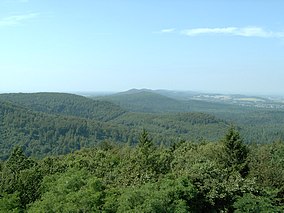
 View over the Teutoburg Forest | |
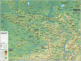
 Teutoburg Forest and Weser Uplands | |
| Location | Germany (north-west) Lower Saxony & NRW |
| Nearest city | Bielefeld Paderborn (to the south) Osnabrück (to the north-west) |
| Coordinates | 51°54′00″N 8°49′00″E / 51.90000°N 8.81667°E |
| Area | c. 4,000 km2 (1,500 sq mi) almost all of it included officially in one of two natural parks: 1,220 km2 (470 sq mi) (TERRA.vita Nature Park) 2,711 km2 (1,047 sq mi) (Teutoburg Forest / Egge Hills Nature Park) |
The Teutoburg Forest (/ˈtjuːtəbɜːrɡ/ TEW-tə-burg; German: Teutoburger Wald [ˈtɔʏtoˌbʊʁɡɐ ˈvalt] ) is a range of low, forested hills in the German states of Lower Saxony and North Rhine-Westphalia. Until the 17th century, the official name of the hill ridge was Osning. It was first renamed the Teutoburg Forest in 1616 in commemoration of the Battle of the Teutoburg Forest in 9 AD, which most likely took place at Kalkriese instead.[1]
- ^ Bordewich, Fergus M. (September 2006). "The Ambush That Changed History". Smithsonian Magazine. Retrieved 14 August 2021.
© MMXXIII Rich X Search. We shall prevail. All rights reserved. Rich X Search