Back The Geysers (tubud sa Tinipong Bansa, California) CEB The Geysers Spanish The Geysers French Geotermalne elektrane Geysers Croatian The Geysers SIMPLE Великі гейзери Ukrainian
| The Geysers | |
|---|---|
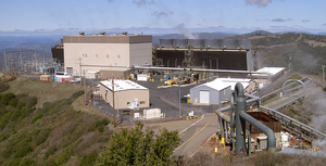
 The Sonoma Calpine 3 power plant is one of 18 power plants at The Geysers | |
 | |
| Official name | The Geysers |
| Country | United States |
| Location | Sonoma and Lake counties California |
| Coordinates | 38°47′26″N 122°45′21″W / 38.79056°N 122.75583°W |
| Status | Operational |
| Commission date | September 1960[1] |
| Owner(s) | Calpine Corporation (86.5%) NCPA (4.5%) Silicon Valley Power (4.5%) USRG (4.5%) |
| Operator(s) | Calpine Corporation |
| Geothermal power station | |
| Type | Dry steam |
| Wells | 376 (active)[1] 591 (total)[1] |
| Max. well depth | 12,900 ft (3,900 m)[1] |
| Site area | 29,000 acres (120 km2)[1] |
| Power generation | |
| Units operational | 22 units (18 power stations) |
| Units planned | 3 units |
| Units decommissioned | 7 units (4 power stations) |
| Nameplate capacity | 1,590 MW[2] |
| Capacity factor | 53%[2] |
| Annual net output | 6,516 GWh (2018)[3] |
| External links | |
| Commons | Related media on Commons |
The Geysers is the world's largest geothermal field, containing a complex of 18 geothermal power plants, drawing steam from more than 350 wells, located in the Mayacamas Mountains approximately 72 miles (116 km) north of San Francisco, California.
Geysers produced about 20% of California's renewable energy in 2019.[4]
- ^ a b c d e "Geysers By The Numbers". geysers.com. Retrieved 2020-02-02.
- ^ a b Brophy, P.; Lippmann, M.; Dobson, P.F.; Poux, B. (2010-10-01). "The Geysers Geothermal Field Update1990/2010". OSTI 1048267. doi:10.2172/1048267. OSTI 1048267. S2CID 129885237.
{{cite journal}}: Cite journal requires|journal=(help) - ^ "Electricity Data Browser - List of plants for geothermal, California, all sectors". www.eia.gov. Retrieved 2020-02-02.
- ^ McCarthy, Will (2020-02-06). "The pros and cons of enhanced geothermal energy systems". Yale Climate Connections. Retrieved 2020-02-17.
© MMXXIII Rich X Search. We shall prevail. All rights reserved. Rich X Search