Back نهر تيبيكانوى ARZ Типикану Bulgarian Tippecanoe River CEB Tippecanoe River German Tippecanoe Finnish Tippecanoe (rivière) French Tippecanoe (rijeka) Croatian Tippecanoe Italian
| Tippecanoe River | |
|---|---|
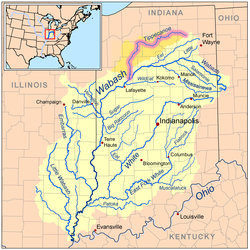
 Map of the Wabash River watershed with the Tippecanoe River highlighted. | |
| Location | |
| Country | US |
| Physical characteristics | |
| Source | |
| • location | Crooked Lake in Noble County, Indiana |
| Mouth | |
• location | Wabash River near Battle Ground, Indiana |
| Length | 182 miles (293 km) |
| Basin size | 1,875 sq mi (4,860 km2) |
| Discharge | |
| • average | 5,110 cu ft/s (145 m3/s) |
| Basin features | |
| Progression | Wabash → Ohio → Mississippi → Gulf of Mexico |
The Tippecanoe River (/ˌtɪpikəˈnuː/ TIP-ee-kə-NOO) is a gentle, 182-mile-long (293 km)[1] river in the Central Corn Belt Plains ecoregion in northern Indiana. It flows from Crooked Lake in Noble County to the Wabash River near what is now Battle Ground, about 12 miles (19 km) northeast of Lafayette. The name "Tippecanoe" was derived from a Miami-Illinois word for buffalo fish, reconstructed as */kiteepihkwana/[2] or as kiteepihkwana siipiiwi.[3]
The Tippecanoe River is fed by 88 natural lakes and has a drainage area of 1,250,000 acres (5,100 km2), spanning 14 counties. It supports more numerous imperiled species and overall species diversity than most streams of the upper Midwest.[4] The Nature Conservancy has identified it as one of the top ten rivers in the United States to preserve due to its ecological diversity and the high proportion of endangered species found in it.[4]
- ^ U.S. Geological Survey. National Hydrography Dataset high-resolution flowline data. The National Map, accessed May 19, 2011
- ^ Bright, William (2004). Native American placenames of the United States. University of Oklahoma Press. p. 496. ISBN 978-0-8061-3598-4. Retrieved 11 April 2011.
- ^ "myaamiaatawaakani | Myaamia Dictionary River names". Archived from the original on 2017-08-30. Retrieved 2017-05-09.
- ^ a b "All about fishing on the Tippecanoe River". The Nature Conservancy. Archived from the original on November 17, 2016. Retrieved April 18, 2014.
© MMXXIII Rich X Search. We shall prevail. All rights reserved. Rich X Search