Back Toce ALS Toce Breton Fiume Toce CEB Toce German Toce jõgi Estonian Toce French Toce ID Toce Italian Tausa Latin Tuss (fiüm) LMO
| Toce | |
|---|---|
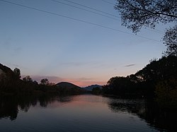
 The river at its confluence with the Strona | |
 Course of the Toce | |
| Location | |
| Country | Italy, Switzerland |
| Physical characteristics | |
| Source | |
| • location | Riale di Formazza |
| Mouth | Lake Maggiore |
• coordinates | 45°56′11″N 8°29′38″E / 45.9365°N 8.4938°E |
| Length | 83.6 km (51.9 mi)[1] |
| Discharge | |
| • average | 69.9 m3/s (2,470 cu ft/s)[2] |
| Basin features | |
| Progression | Lake Maggiore→ Ticino→ Po→ Adriatic Sea |
The Toce (Italian pronunciation: [ˈtoːtʃe; ˈtɔːtʃe]) is a river in Piedmont, Italy, which stretches the length of the Val d'Ossola from the Swiss border to Lake Maggiore into which it debouches near Fondotoce in the commune of Verbania. The river is 83.6 kilometres (51.9 mi) long[1] and is formed in the upper Val Formazza by the confluence of a number of torrents in the plain of Riale.
- ^ a b Caratterizzazione bacini Idrografici (elab.I.a/5) - Allegato tecnico al Piano di Tutela delle Acque Archived 2012-02-25 at the Wayback Machine (Regione Piemonte, 1 July 2004).
- ^ AA.VV. (2004). "Elaborato I.c/7". Piano di Tutela delle Acque - Revisione del 1º luglio 2004; Caratterizzazione bacini Idrografici (PDF). Regione Piemonte. Archived from the original (PDF) on 2012-02-25. Retrieved 2014-01-07.
© MMXXIII Rich X Search. We shall prevail. All rights reserved. Rich X Search