| Tolo Highway | |
|---|---|
| Part of Route 9 | |
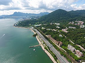
 Aerial view of Tolo Highway at Tai Po Kau | |
| Route information | |
| Maintained by Highways Department | |
| Length | 11.3 km (7.0 mi) |
| Existed | 1987–present |
| Major junctions | |
| East end | Sha Tin (near Ma Liu Shui) |
| 8 in total; | |
| West end | Tai Po (Tai Hang San Wai) |
| Location | |
| Country | China |
| Special administrative region | Hong Kong |
| Highway system | |

Tolo Highway (Chinese: 吐露港公路; Cantonese Yale: tou3 lou6 gong2 gung1 lou6) is a major expressway on Route 9 in Hong Kong. It connects the new towns of Sha Tin and Tai Po in the eastern New Territories, forming part of the New Territories Circular Road.
The 11.3-kilometre (7.0 mi) highway, constructed in three stages between 1985 and 1987, was so named as it skirts the western edge of Tolo Harbour.
© MMXXIII Rich X Search. We shall prevail. All rights reserved. Rich X Search

