Back المثلث (إسرائيل) Arabic المثلث (تجمع سكان فى المنطقه الوسطى) ARZ Triangle (Israel) Catalan Trojúhelník (Izrael) Czech Meschulasch German Triángulo (Israel) Spanish Triangle (Israël) French המשולש HE Segitiga (Israel) ID Triangolo (Israele) Italian


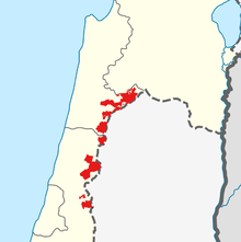
The Triangle (Hebrew: המשולש, HaMeshulash; Arabic: المثلث, al-Muthallath), formerly referred to as the Little Triangle, is a concentration of Israeli Arab towns and villages adjacent to the Green Line, located in the eastern Sharon plain among the Samarian foothills; this area is located within the easternmost boundaries of both the Central District and Haifa District. The eleven towns are home to approximately 250,000 Arab citizens of Israel, representing between 10-15% of Israel's Palestinian Arab population.[2]
The Triangle is further divided into the "Northern Triangle" or Wadi Ara[3] (around Kafr Qara, Ar'ara, Baqa al-Gharbiyye, Zemer and Umm al-Fahm) and the "Southern Triangle" (around Qalansawe, Tayibe, Kafr Qasim, Tira, Kafr Bara and Jaljulia). Umm al-Fahm and Tayibe are the social, cultural and economic centers for Arab residents of the region. The Triangle is a stronghold of the Islamic Movement in Israel and Raed Salah, the current leader of the movement's northern faction, is a former mayor of Umm al-Fahm.
- ^ Cite error: The named reference
MakdisiSilverstein2006was invoked but never defined (see the help page). - ^ Report: Netanyahu suggested to US that Arab Israeli towns be placed in Palestine, Times of Israel, 4 February 2020
- ^ Hillel Cohen (6 January 2010). Good Arabs: The Israeli Security Agencies and the Israeli Arabs, 1948–1967. University of California Press. p. 15. ISBN 978-0-520-94488-6.
... the villages of Wadi Ara (the area called the northern Triangle)...
© MMXXIII Rich X Search. We shall prevail. All rights reserved. Rich X Search
