Back نهر ترومبيتاس ARZ Rio Trombetas CEB Тромбетас (юханшыв) CV Ποταμός Τρομπέτας Greek Trombetas (rivero) Esperanto Río Trombetas Spanish Trombetas Basque Rio Trombetas French Trombetasas Lithuanian Trombetas Dutch
| Trombetas River | |
|---|---|
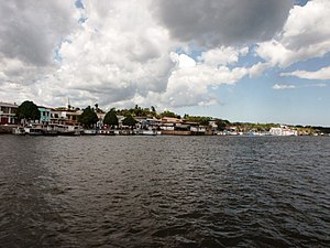
 The city of Oriximiná on the banks of the Trombetas near its confluence with the Amazon | |
| Location | |
| Country | Brazil |
| State | Pará |
| Physical characteristics | |
| Source | confluence of Anamu River and Poana River (parts of Anamu sometimes included in the Trombetas on maps, in which case Poana is a right tributary) |
| • location | Pará, Brazil |
| Mouth | Amazon River |
• location | Pará, Brazil |
• coordinates | 1°52′52″S 55°38′10″W / 1.88111°S 55.63611°W |
| Length | 760 km (470 mi)[1] |
| Basin size | 135,238 km2 (52,216 sq mi)[2] |
| Discharge | |
| • average | 3,437 m3/s (121,400 cu ft/s) |
| Basin features | |
| Tributaries | |
| • left | Paru de Oeste River (Erepecuru River/Cuminá River) |
| • right | Mapuera River, Cachorro River |

The Trombetas is a large river on the northern side of the Amazon River.
- ^ Ziesler, R.; Ardizzone, G.D. (1979). "Amazon River System". The Inland waters of Latin America. Food and Agriculture Organization of the United Nations. ISBN 92-5-000780-9. Archived from the original on 8 November 2014.
- ^ Para-regionen Archived 2014-12-02 at the Wayback Machine – «Bacias Hidrográficas do Pará».
© MMXXIII Rich X Search. We shall prevail. All rights reserved. Rich X Search
