This article needs additional citations for verification. (January 2023) |
| Tropical cyclones in 2023 | |
|---|---|
 Year summary map | |
| Year boundaries | |
| First system | 03F |
| Formed | January 5, 2023 |
| Last system | Alvaro |
| Dissipated | January 3, 2024 |
| Strongest system | |
| Name | Mawar |
| Lowest pressure | 900 mbar (hPa); 26.58 inHg |
| Longest lasting system | |
| Name | Freddy (Longest-lasting tropical system on record) |
| Duration | 37 days |
| Year statistics | |
| Total systems | 115 (+ 1 unofficial) |
| Named systems | 79 (+ 1 unofficial) |
| Total fatalities | 8,234 (26)[a] |
| Total damage | > $92.715 billion (2023 USD) |

Among them, Mawar (second image in the second row) was the most intense with a minimum central pressure of 900 hPa.
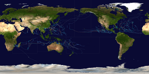
During 2023, tropical cyclones formed in seven major bodies of water, commonly known as tropical cyclone basins. They were named by various weather agencies when they attained maximum sustained winds of 35 knots (65 km/h; 40 mph). Throughout the year, a total of 115 systems formed, with 79 of them being named. The most intense storm this year was Typhoon Mawar, which had a minimum pressure of 900 hPa (26.58 inHg). The deadliest tropical cyclone of the year was Storm Daniel, which killed at least 10,028 people in Libya, Greece, Turkey, and Bulgaria. Meanwhile, the costliest tropical cyclone was Typhoon Doksuri which caused at least US$28.4 billion worth of damage in China, the Philippines and Taiwan, becoming the costliest on record outside the Atlantic Ocean basin. Among this year's systems, thirty became major tropical cyclones, of which nine intensified into Category 5 tropical cyclones on the Saffir–Simpson scale (SSHWS). This year, for the first time on record, at least one such Category 5 system formed in each tropical cyclone basin:[1] Typhoons Mawar and Bolaven in the western Pacific Ocean, Hurricanes Jova and Otis in the eastern Pacific, Hurricane Lee in the Atlantic, Cyclone Mocha in the North Indian Ocean, Cyclone Freddy in the southwest Indian Ocean, Cyclone Ilsa in the Australian region, and Cyclone Kevin in the South Pacific. The accumulated cyclone energy (ACE) index for the 2023 (seven basins combined), as calculated by Colorado State University (CSU) was 857.4 units, which was above the 1991-2020 mean of 770.2 units.[2][3]
The most active basin in the year was the North Atlantic Ocean, which had 20 named systems. The Eastern Pacific Ocean had an above-average and destructive season, with 17 named storms forming; 10 of those became hurricanes, of which 8 strengthened into major hurricanes – double the seasonal average. The Western Pacific Ocean had a total of 17 named storms, making it the second least active season in the basin, tying with 1998. The North Indian Ocean was unusually active, with six named storms forming, producing the second-most accumulated cyclone energy in this basin on record, only behind 2019. Activity across the southern hemisphere's three basins (South-West Indian, Australian, and South Pacific) was fairly significant, with the regions recording 17 named storms altogether, with the most intense Southern Hemisphere cyclone of the year, Cyclone Kevin in the South Pacific basin, peaking with a central pressure of 913 hPa (26.96 inHg).
Tropical cyclones were primarily monitored by ten warning centers across the world, which are designated as a Regional Specialized Meteorological Center (RSMC) or a Tropical Cyclone Warning Center (TCWC) by the World Meteorological Organization (WMO). These ten centers are the National Hurricane Center (NHC) and the Central Pacific Hurricane Center (CPHC), Japan Meteorological Agency (JMA), Indian Meteorological Department (IMD), Météo-France (MFR), Indonesia's Meteorology, Climatology, and Geophysical Agency (BMKG), the Australian Bureau of Meteorology (BoM), Papua New Guinea's National Weather Service (PNGNWS), the Fiji Meteorological Service (FMS), and New Zealand's MetService. Unofficial, but still notable, warning centres include the Philippine Atmospheric, Geophysical and Astronomical Services Administration (PAGASA), the United States's Joint Typhoon Warning Center (JTWC), and the Brazilian Navy Hydrographic Center.
Cite error: There are <ref group=lower-alpha> tags or {{efn}} templates on this page, but the references will not show without a {{reflist|group=lower-alpha}} template or {{notelist}} template (see the help page).
- ^ Masters, Jeff; Henson, Bob (September 8, 2023). "Hurricane Lee peaks as a Cat 5 with 165-mph winds". New Haven, Connecticut: Yale Climate Connections. Retrieved September 8, 2023.
- ^ "Annual 2023 Tropical Cyclones Report". Retrieved 25 March 2024.
- ^ "Global Metrics of Tropical Cyclones".
© MMXXIII Rich X Search. We shall prevail. All rights reserved. Rich X Search
