Back أرومية Arabic ܐܘܪܡܝܐ ARC اروميه ARZ Urmiya Azerbaijani اورمیه AZB Урмія (горад) Byelorussian Урмия Bulgarian Urmia Catalan Orūmīyeh (kapital sa lalawigan sa Iran) CEB ورمێ CKB
Urmia
ارومیه | |
|---|---|
City | |
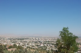
Clockwise from top: Skyline of the city, Jameh Mosque of Urmia, Segonbad | |
| Nickname: Cradle of Water | |
| Coordinates: 37°32′38″N 45°03′53″E / 37.54389°N 45.06472°E[1] | |
| Country | Iran |
| Region | 3 |
| Province | West Azerbaijan |
| County | Urmia |
| Bakhsh | Central |
| Government | |
| • Mayor | Hossein Mahdizadeh |
| • Parliament | Vahid Jalalzadeh, Salman Zaker & Ruhollah Hazratpour |
| Elevation | 1,332 m (4,370 ft) |
| Population (2016 census) | |
| • Urban | 736,224[2] |
| • Metro | 1,000,000[citation needed] |
| • Population Rank in Iran | 10th |
| Time zone | UTC+3:30 (IRST) |
| Area code | 044 |
| Website | urmia |
 | |
Urmia (Persian: ارومیه; pronounced [oɾumiˈje] )[a] is the largest city in West Azerbaijan Province of Iran. In the Central District of Urmia County, it is capital of the province, the county, and the district.[5]
The city lies at an altitude of 1,330 metres (4,360 ft) above sea level along the Shahar River on the Urmia Plain. Lake Urmia, one of the world's largest salt lakes, lies to the east of the city, and the border with Turkey lies to the west.
The city is the trading center for a fertile agricultural region where fruits (especially apples and grapes) and tobacco are grown. Even though the majority of the residents of Urmia are Muslims, the Christian history of Urmia is well preserved and is especially evident in the city's many churches and cathedrals.
An important town by the 9th century, the city has had a diverse population which has at times included Muslims (Shias and Sunnis), Christians (Catholics, Protestants, Nestorians, and Orthodox), Jews, Baháʼís and Sufis. Around 1900 Christians made up more than 40% of the city's population; however, in the next decades most of the Christians were either killed by the advancing Ottoman troops or in raids by Kurdish tribes[6][7] or fled shortly after the end of the war.[8][9][10]
Urmia, Takab and Piranshahr respectively have the highest number of registered provincial sites in the list of national sites.[11]
- ^ OpenStreetMap contributors (17 February 2024). "Urmia, Urmia County" (Map). OpenStreetMap. Retrieved 17 February 2024.
- ^ Cite error: The named reference
2016 censuswas invoked but never defined (see the help page). - ^ "Orūmīyeh | Iran | Britannica".
- ^ Urmia can be found at GEOnet Names Server, at this link, by opening the Advanced Search box, entering "-3077456" in the "Unique Feature Id" form, and clicking on "Search Database".
- ^ Habibi, Hassan (7 July 1369). "Approval of the organization and chain of citizenship of the elements and units of the country divisions of West Azerbaijan province, centered in the city of Urmia". Lamtakam (in Persian). Ministry of Interior, Council of Ministers. Archived from the original on 20 December 2023. Retrieved 20 December 2023.
- ^ Hellot-Bellier, Florence (2019). "The Resistance of Urmia Assyrians to Violence at the Beginning of the Twentieth Century". Let Them Not Return: Sayfo – The Genocide Against the Assyrian, Syriac, and Chaldean Christians in the Ottoman Empire. Vol. 26 (1 ed.). Berghahn Books. pp. 71, 95, 96. doi:10.2307/j.ctvw049wf.8. ISBN 978-1-78533-498-6. JSTOR j.ctvw049wf.8.
- ^ Gaunt, David (2006). "Playing with Fire: Occupied Urmia". Massacres, Resistance, Protectors: Muslim-Christian Relations in Eastern Anatolia during World War I. Gorgias Press. pp. 81–120. doi:10.31826/9781463210816-009. ISBN 978-1-4632-1081-6.
- ^ "Urmia | Encyclopedia.com".
- ^ "Assyrians in the History of Urmia, Iran".
- ^ E. J. Brill's First Encyclopaedia of Islam, 1913–1936, M. Th Houtsma, p. 1035, 1987
- ^ "ثبت ۳۴۳۱ قلم اثر آذربایجان غربی در سامانه جامع میراث فرهنگی کشور". 17 May 2022.
Cite error: There are <ref group=lower-alpha> tags or {{efn}} templates on this page, but the references will not show without a {{reflist|group=lower-alpha}} template or {{notelist}} template (see the help page).
© MMXXIII Rich X Search. We shall prevail. All rights reserved. Rich X Search


