Back فـان بيرن (مين) Arabic فان بيرن ARZ وان بورن (کدپ)، مئین AZB Van Buren (condado de Aroostook) Spanish ون بیورن، مین (ناحیه سرشماری) Persian Van Buren (Maine, statisztikai település) Hungarian Van Buren (hrabstwo Aroostook) Polish Ван-Бюрен (сан алу урыны, Мэн) Tatar Ван-Бюрен (переписна місцевість, Мен) Ukrainian 范布倫 (緬因州普查規定居民點) Chinese
Van Buren, Maine | |
|---|---|
 View of Van Buren from Canada | |
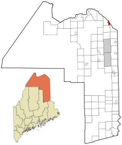
 Location of Van Buren, Maine | |
| Coordinates: 47°9′54″N 67°56′28″W / 47.16500°N 67.94111°W | |
| Country | United States |
| State | Maine |
| County | Aroostook |
| Town | Van Buren |
| Area | |
| • Total | 4.65 sq mi (12.04 km2) |
| • Land | 4.32 sq mi (11.20 km2) |
| • Water | 0.33 sq mi (0.84 km2) |
| Elevation | 482 ft (147 m) |
| Population (2020) | |
| • Total | 1,809 |
| • Density | 418.46/sq mi (161.57/km2) |
| Time zone | UTC-5 (Eastern (EST)) |
| • Summer (DST) | UTC-4 (EDT) |
| ZIP code | 04785 |
| Area code | 207 |
| FIPS code | 23-78535 |
| GNIS feature ID | 0577687 |
Van Buren is a census-designated place (CDP) comprising the main village within the town of Van Buren in Aroostook County, Maine, United States. The population of the CDP was 1,937 at the 2010 census,[2] out of a population of 2,171 for the entire town.
- ^ "2020 U.S. Gazetteer Files". United States Census Bureau. Retrieved April 8, 2022.
- ^ "Geographic Identifiers: 2010 Demographic Profile Data (G001): Van Buren CDP, Maine". U.S. Census Bureau, American Factfinder. Archived from the original on February 12, 2020. Retrieved May 22, 2013.
© MMXXIII Rich X Search. We shall prevail. All rights reserved. Rich X Search