Back ولاية الأرخبيل Arabic Cəzayir-i bəhr-i səfid vilayəti Azerbaijani Vilâyet Cezayir German Βιλαέτι του Αρχιπελάγους Greek Valiato del Archipiélago Spanish ولایت جزایر بحر سفید Persian Vilayet de l'Archipel French Vilayet dell'Arcipelago Italian Arhipelāga vilājets Latvian/Lettish ولایت مجموعہ الجزائر PNB
| Vilayet of the Archipelago | |||||||||||||||
|---|---|---|---|---|---|---|---|---|---|---|---|---|---|---|---|
| Vilayet of the Ottoman Empire | |||||||||||||||
| 1867–1913 | |||||||||||||||
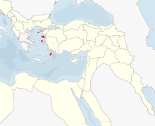
 The Vilayet of the Archipelago and the Vilayet of Crete in 1890 | |||||||||||||||
| Capital | Kale-i Sultaniye, Chios, Rhodes | ||||||||||||||
| Area | |||||||||||||||
• 1885[1] | 12,850 km2 (4,960 sq mi) | ||||||||||||||
| Population | |||||||||||||||
• 1885[1] | 325,866 | ||||||||||||||
| History | |||||||||||||||
| 1867 | |||||||||||||||
• Disestablished | 1913 | ||||||||||||||
| |||||||||||||||
| area does not include Cyprus | |||||||||||||||
The Vilayet of the Archipelago (Ottoman Turkish: ولايت جزائر بحر سفيد, Vilâyet-i Cezair-i Bahr-i Sefid,[2][3] "Vilayet of the Islands of the Mediterranean Sea") was a first-level administrative division (vilayet) of the Ottoman Empire extant from 1867 to 1912–13, including, at its maximum extent, the Ottoman Aegean islands, Cyprus and the Dardanelles Strait.
At the beginning of the 20th century, it reportedly had an area of 4,963 square miles (12,850 km2), while the preliminary results of the first Ottoman census of 1885 (published in 1908) gave the population as 325,866.[1] The accuracy of the population figures ranges from "approximate" to "merely conjectural" depending on the region from which they were gathered.[1]
- ^ a b c Asia by A. H. Keane, page 459
- ^ Salname-yi Vilâyet-i Cezair-i Bahr-i Sefid ("Yearbook of the Vilayet of Cezair-i Bahr-i Sefid"), Cezair-i Bahr-i Sefid vilâyet matbaası, Rodos [Greece], 1293 [1876]. in the website of Hathi Trust Digital Library.
- ^ سالنامئ ولايت جزائر بحر سفيد
© MMXXIII Rich X Search. We shall prevail. All rights reserved. Rich X Search

